IMAGES TAKEN NEAR TO
Annadale Gardens, BELFAST, BT7 3DS
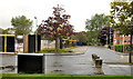
Introduction
This page details the photographs taken nearby to Annadale Gardens, BT7 3DS by members of the Geograph project.
The Geograph project started in 2005 with the aim of publishing, organising and preserving representative images for every square kilometre of Great Britain, Ireland and the Isle of Man.

There are currently over 7.5m images from over14,400 individuals and you can help contribute to the project by visiting https://www.geograph.org.uk
Image Map
Images are licensed for reuse under creativecommons.org/licenses/by-sa/2.0
Notes
- Clicking on the map will re-center to the selected point.
- The higher the marker number, the further away the image location is from the centre of the postcode.
Image Listing (342 Images Found)
Images are licensed for reuse under creativecommons.org/licenses/by-sa/2.0
Image
Details
Distance
1
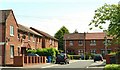
Annadale Drive, Belfast
A separate entity from the nearby Annadale Flats Image, Annadale Drive and the other houses here were built by the old Belfast Corporation to a standard design (similar ones may be found at Edenvale, Strandtown) Image Some in the photo have been modernised externally but the one in Annadale Crescent (in front of the car on the right) is close to the original design. The moral of the story might be “don’t depart from the tried and trusted red-brick terrace”.
Image: © Albert Bridge
Taken: 5 Jun 2009
0.04 miles
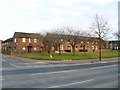
2
Annadale Green, Belfast (January 2017)
Apartments in the Annadale Village development.
Image: © Albert Bridge
Taken: 11 Jan 2017
0.05 miles
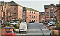
3
Annadale Terrace, Belfast
A row of red-brick terraced house - constructed in the 1950s along Annadale Embankment.
Image: © Dean Molyneaux
Taken: 10 Mar 2010
0.06 miles
4
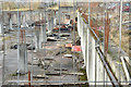
The Embankment development, Annadale, Belfast (January 2017)
The uncompleted site at Annadale Drive/Annadale Crescent.
Image: © Albert Bridge
Taken: 11 Jan 2017
0.06 miles
5
"The Embankment", Belfast (4)
The vacant site, behind the black and yellow hoarding, seen from Annadale Green. Annadale Drive is on the right.
Image: © Albert Bridge
Taken: 14 Sep 2011
0.07 miles
6
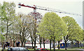
Builder's crane, The Embankment, Belfast (April 2017)
Miracles do happen. A new crane and work re-started on this site abandoned during the recession in 2011.
Image: © Albert Bridge
Taken: 27 Apr 2017
0.07 miles
7
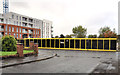
"The Embankment", Belfast (3)
The completed and occupied part of the development is on the left. The site, behind the black and yellow hoarding, is vacant. The crane Image remains (top left). The view is from Annadale Green to Annadale Crescent.
Image: © Albert Bridge
Taken: 14 Sep 2011
0.07 miles
8

Laurel berries, Belfast
Berries, on a laurel growing between the Annadale Embankment Image and the Lagan, near the Governor’s Bridge. They have a passing resemblance to cherries but contain a toxin which makes them unsuitable for human consumption. Image shows the unripe (green) berries. See also Image
Image: © Albert Bridge
Taken: 15 Sep 2010
0.08 miles
9
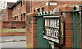
Annadale Terrace sign, Belfast
Tiled sign, mounted on a concrete post, at the Annadale Crescent end of Annadale Terrace - visible (middle left) in Image – March 2010.
Image: © Albert Bridge
Taken: 8 Mar 2012
0.08 miles
10
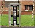
Telephone box, Annadale, Belfast
A KX300 (I think) telephone box on the Annadale Embankment.
Image: © Albert Bridge
Taken: 8 Mar 2012
0.08 miles