IMAGES TAKEN NEAR TO
Hampton Grove, BELFAST, BT7 3DG
Introduction
This page details the photographs taken nearby to Hampton Grove, BT7 3DG by members of the Geograph project.
The Geograph project started in 2005 with the aim of publishing, organising and preserving representative images for every square kilometre of Great Britain, Ireland and the Isle of Man.

There are currently over 7.5m images from over14,400 individuals and you can help contribute to the project by visiting https://www.geograph.org.uk
Image Map
Images are licensed for reuse under creativecommons.org/licenses/by-sa/2.0
Notes
- Clicking on the map will re-center to the selected point.
- The higher the marker number, the further away the image location is from the centre of the postcode.
Image Listing (365 Images Found)
Images are licensed for reuse under creativecommons.org/licenses/by-sa/2.0
Image
Details
Distance
1
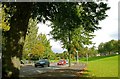
The Annadale Embankment, Belfast (3)
See Image That part of the Annadale Embankment used by vehicles (one way system) looking towards the King’s Bridge Image Continue to Image
Image: © Albert Bridge
Taken: 3 Oct 2008
0.02 miles
2
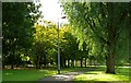
The Annadale Embankment, Belfast (2)
See Image The footpath, on the eastern side, is lined by rows of mature trees. The view is towards Annadale Flats (behind the trees in the background). Continue to Image
Image: © Albert Bridge
Taken: 3 Oct 2008
0.03 miles
3

New watermain, Annadale, Belfast (2)
See Image Most of the pipeline seen in the previous photo seems to have been buried. This bit of pipe is between the Lagan and the Annadale Embankment. Continue to Image
Image: © Albert Bridge
Taken: 20 Aug 2010
0.04 miles
4

New watermain, Annadale, Belfast (3)
See Image Part of the old main, between the Lagan and the Annadale Embankment – presumably awaiting removal.
Image: © Albert Bridge
Taken: 20 Aug 2010
0.05 miles
5
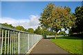
The Annadale Embankment, Belfast (1)
See Image The Annadale Embankment is the second of the three Lagan embankments. From the pedestrian’s viewpoint it has the advantage of two footpaths which are remote from the road. This one, on the western side, has the Lagan behind the fence on the left while the road is screened behind the trees on the right. The view is towards the King’s Bridge Image Continue to Image
Image: © Albert Bridge
Taken: 3 Oct 2008
0.05 miles
6
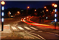
Zebra crossing, Belfast (2)
A well-lit zebra crossing at the Annadale Embankment end of the Governor’s Bridge (background). See also Image
Image: © Albert Bridge
Taken: 27 Oct 2009
0.05 miles
7
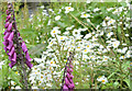
Wildflowers, River Lagan, Belfast - June 2016(2)
See Image Part of the growth of ox-eye daisies and foxgloves on the Annadale bank.
Image: © Albert Bridge
Taken: 17 Jun 2016
0.05 miles
8
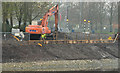
Revetment works, River Lagan, Belfast - April 2014(2)
The work is nearing completion. Most of the contractor’s machinery has been removed. The gloomy mist is probably the Sahara dust mentioned in the shared description (below).
Image: © Albert Bridge
Taken: 3 Apr 2014
0.05 miles
9

Laurel berries, Belfast (2012)
See Image (September 2010). Some of the 2012 crop of laurel along the Annadale Embankment. Remember that, however eye catching and attractive, they are not suitable for human consumption.
Image: © Albert Bridge
Taken: 17 Aug 2012
0.06 miles
10
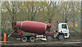
Revetment works, River Lagan, Belfast - April 2014(1)
A lorry making a delivery of ready-mix concrete to the site close to the Annadale Embankment. The gloomy mist is probably the Sahara dust mentioned in the shared description (below).
Image: © Albert Bridge
Taken: 3 Apr 2014
0.06 miles