IMAGES TAKEN NEAR TO
Annadale Embankment, BELFAST, BT7 3AE
Introduction
This page details the photographs taken nearby to Annadale Embankment, BT7 3AE by members of the Geograph project.
The Geograph project started in 2005 with the aim of publishing, organising and preserving representative images for every square kilometre of Great Britain, Ireland and the Isle of Man.

There are currently over 7.5m images from over14,400 individuals and you can help contribute to the project by visiting https://www.geograph.org.uk
Image Map
Images are licensed for reuse under creativecommons.org/licenses/by-sa/2.0
Notes
- Clicking on the map will re-center to the selected point.
- The higher the marker number, the further away the image location is from the centre of the postcode.
Image Listing (275 Images Found)
Images are licensed for reuse under creativecommons.org/licenses/by-sa/2.0
Image
Details
Distance
1
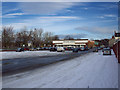
Supermarket, Belfast
'Dunne's Stores' http://www.geograph.org.uk/search.php?i=17484841 supermarket on Annadale Embankment in Belfast.
Image: © Rossographer
Taken: 9 Dec 2010
0.01 miles
3
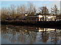
The River Lagan at Annadale Embankment
Looking across the Lagan to the 'Dunne's Stores' supermarket on Annadale Embankment.
Image: © Rossographer
Taken: 26 Jan 2009
0.01 miles
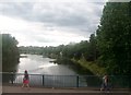
4
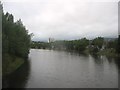
The River Lagan from the Ormeau Bridge.
This is the view upstream.
Image: © Eric Jones
Taken: 19 Aug 2009
0.04 miles
5

The Annadale Embankment, Belfast (6)
See Image The northern end of the Annadale Embankment as it approaches the Ormeau Road and the Ormeau Bridge. The Lagan is behind the trees on the right.
Image: © Albert Bridge
Taken: 15 May 2010
0.04 miles
6
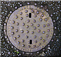
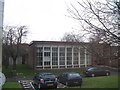
Manhole cover, Belfast
Manhole cover located in an entry between Delhi Street and Baroda Street in Belfast (the Google map shows this as Delhi Street North). It is marked "James Stewart, Sandy Row Foundry, Belfast". One of several identical covers in the area, although this example was in a particularly fine condition. See also Image - for the record, I cannot find the location of the foundry, although a 'Smithy' is marked on 1901 OS maps at the corner of Moore's Place and the Donegall Road which lies at the southern end of Sandy Row.
Image: © Rossographer
Taken: 15 Mar 2011
0.04 miles
7
The River Lagan above Ormeau Road Bridge
Image: © Eric Jones
Taken: 21 Jul 2014
0.04 miles

9
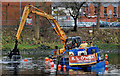
Dredging the River Lagan, Belfast - 2010/11 (89)
A view, from the Stranmillis Embankment, of the crane barge at work near the Annadale Embankment (background).
Image: © Albert Bridge
Taken: 15 Dec 2010
0.04 miles
10
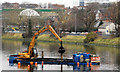
Dredging the River Lagan, Belfast - 2010/11 (90)
The crane barge at the same spot in the Lagan as in Image but viewed from the southern end of the Ormeau Bridge.
Image: © Albert Bridge
Taken: 15 Dec 2010
0.04 miles