IMAGES TAKEN NEAR TO
Lower Stanfield Street, BELFAST, BT7 2HB
Introduction
This page details the photographs taken nearby to Lower Stanfield Street, BT7 2HB by members of the Geograph project.
The Geograph project started in 2005 with the aim of publishing, organising and preserving representative images for every square kilometre of Great Britain, Ireland and the Isle of Man.

There are currently over 7.5m images from over14,400 individuals and you can help contribute to the project by visiting https://www.geograph.org.uk
Image Map
Images are licensed for reuse under creativecommons.org/licenses/by-sa/2.0
Notes
- Clicking on the map will re-center to the selected point.
- The higher the marker number, the further away the image location is from the centre of the postcode.
Image Listing (855 Images Found)
Images are licensed for reuse under creativecommons.org/licenses/by-sa/2.0
Image
Details
Distance
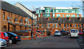
1
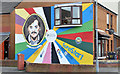
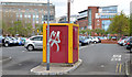
"Sure Start" mural, Belfast
A mural at Lower Stanfield Street marking the “Sure Start” programme http://www.belfastmarkets.com/?page_id=1044 operated locally by Belfast City Council.
Image: © Albert Bridge
Taken: 15 May 2013
0.01 miles
2
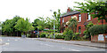
Eliza Street, Belfast
The original Eliza Street ran from Cromac Street through to Stewart Street and was best known as the home of the Inglis bakery. Redeveloped and now a short street off Cromac Street. Ex-pats will be surprised at the amount of greenery – especially the flowering palm (right).
Image: © Albert Bridge
Taken: 28 Jun 2010
0.04 miles
3
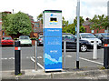
E-car charging point, Belfast (2)
An E-car charging point at the Market Street side of Eliza Street car park Image
Image: © Albert Bridge
Taken: 15 May 2013
0.06 miles
4
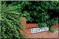
Eliza Street sign, Belfast
The sign at the Cromac Street end of Eliza Street Image – not branded as the “Markets Quarter”.
Image: © Albert Bridge
Taken: 28 Jun 2010
0.07 miles
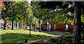
5
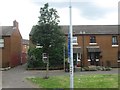
Stanfield Place, Belfast
Redeveloped street in The Markets, off Upper Stanfield Street.
Image: © Albert Bridge
Taken: 17 Feb 2010
0.07 miles
6
Friendly Street, Belfast (2)
See Image The view towards Stewart Street as Friendly Street curves towards Cromac Street. East Bridge Street is on the left.
Image: © Albert Bridge
Taken: 17 Sep 2010
0.07 miles
7
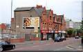
Cromac Street, Belfast (3)
See Image The houses have all been redeveloped but this row of shops (between Catherine Street and Henrietta Street) lies vacant. Continue to Image (May 2013).
Image: © Albert Bridge
Taken: 28 Jun 2010
0.07 miles
8
Eliza Terrace, Belfast
See Image Eliza Terrace is well hidden from Cromac Street by the landscaping on the left. The house nearest the camera was having a spot of work done.
Image: © Albert Bridge
Taken: 28 Jun 2010
0.07 miles
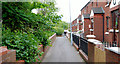
9
Eliza Street car park, Belfast
See Image Most (if not all) NCP-staffed Roads Service car parks seem to have been converted to pay and display. Checking is done by mobile NCP attendants on mopeds.
Image: © Albert Bridge
Taken: 15 May 2013
0.07 miles
10
Modern terraced housing in the Nationalist Markets area off East Bridge Street
Image: © Eric Jones
Taken: 26 Jun 2017
0.07 miles