IMAGES TAKEN NEAR TO
Jameson Street, BELFAST, BT7 2GU
Introduction
This page details the photographs taken nearby to Jameson Street, BT7 2GU by members of the Geograph project.
The Geograph project started in 2005 with the aim of publishing, organising and preserving representative images for every square kilometre of Great Britain, Ireland and the Isle of Man.

There are currently over 7.5m images from over14,400 individuals and you can help contribute to the project by visiting https://www.geograph.org.uk
Image Map
Images are licensed for reuse under creativecommons.org/licenses/by-sa/2.0
Notes
- Clicking on the map will re-center to the selected point.
- The higher the marker number, the further away the image location is from the centre of the postcode.
Image Listing (133 Images Found)
Images are licensed for reuse under creativecommons.org/licenses/by-sa/2.0
Image
Details
Distance
1
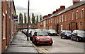
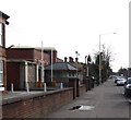
Raby Street, Belfast
A street, of traditional terraces houses (mainly built in the early 20th century), running from the Ormeau Road to St Jude’s Crescent (background).
Image: © Albert Bridge
Taken: 14 Sep 2011
0.02 miles
2
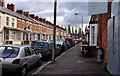
Jameson Street, Belfast (1)
A late 19th century street, running from the Ormeau Road to St Jude’s Crescent (background).
Image: © Albert Bridge
Taken: 17 Sep 2011
0.04 miles
3
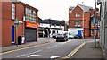
The disused Ballynafeigh Ormeau Road PSNI station
This station was closed in 2011.
http://www.bbc.co.uk/news/uk-northern-ireland-13380554
Image: © Eric Jones
Taken: 27 Apr 2012
0.05 miles
4
Sunnyside Street, Belfast (1)
Sunnyside Street runs from the Annadale Embankment to the Ormeau Road. Although the first houses were built in the 1870’s the street was not completed until the early 20th century. This is the Ormeau Road end. Continue to Image
Image: © Albert Bridge
Taken: 14 Sep 2010
0.05 miles
5
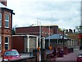
The mothballed Ballynafeigh (Ormeau Road) PSNI Station
South Belfast has four police stations, Ballynafeigh, Musgrave, Donegall Pass and Lisburn Road. Two of these - Ballynafeigh and Donegall Pass - are no longer open to the public.
http://www.psni.police.uk/south_belfast_plan_1011.pdf
Image
Image: © Eric Jones
Taken: 17 Feb 2015
0.05 miles
6

Former Ballynafeigh police station, Belfast - March 2017(2)
Part of the former police station with the “sold” sign. The building on the left was known as a “sangar” (a term borrowed from HM forces) and housed a guard/outside receptionist (usually a Reserve constable).
Image: © Albert Bridge
Taken: 31 Mar 2017
0.05 miles
7

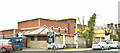
Former Ballynafeigh police station, Belfast - March 2017(1)
See Image (February 2015). The main building facing the Ormeau Road.
Image: © Albert Bridge
Taken: 31 Mar 2017
0.05 miles
8
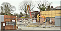
Former Ballynafeigh police station, Belfast (April 2019)
Now demolished.
Image: © Albert Bridge
Taken: 14 Apr 2019
0.05 miles
9
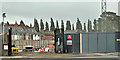
No 332 Ormeau Road, Belfast (October 2019)
The site of the former Ballynafeigh police station. Work has now started on the construction of apartments.
Image: © Albert Bridge
Taken: 5 Oct 2019
0.06 miles
10
Former Ballynafeigh police station, Belfast (April 2018)
The former police station at 332 Ormeau Road, currently the subject of public consultation before an application for planning permission to build apartments on the site. The photograph does not show the large area behind the building - previously used for vehicle parking.
Image: © Albert Bridge
Taken: 13 Apr 2018
0.06 miles