IMAGES TAKEN NEAR TO
Rutland Street, BELFAST, BT7 2FJ
Introduction
This page details the photographs taken nearby to Rutland Street, BT7 2FJ by members of the Geograph project.
The Geograph project started in 2005 with the aim of publishing, organising and preserving representative images for every square kilometre of Great Britain, Ireland and the Isle of Man.

There are currently over 7.5m images from over14,400 individuals and you can help contribute to the project by visiting https://www.geograph.org.uk
Image Map
Images are licensed for reuse under creativecommons.org/licenses/by-sa/2.0
Notes
- Clicking on the map will re-center to the selected point.
- The higher the marker number, the further away the image location is from the centre of the postcode.
Image Listing (299 Images Found)
Images are licensed for reuse under creativecommons.org/licenses/by-sa/2.0
Image
Details
Distance
1
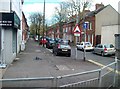
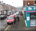
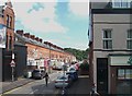
Rutland Street, Belfast
A street of late 19th century terrace houses running from the Ormeau Road towards the Lagan. In common with most of the streets locally, it has traffic-calming humps.
Image: © Albert Bridge
Taken: 30 Apr 2010
0.02 miles
2
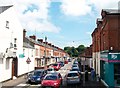
Rutland Street off the Lower Ormeau Road
Image: © Eric Jones
Taken: 10 Jul 2015
0.02 miles
3
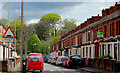
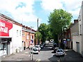
Farnham Street, Belfast
A street of late 19th century houses running from Belfour Avenue Image and the Lagan to the Ormeau Road (background).
Image: © Albert Bridge
Taken: 27 Feb 2010
0.03 miles
4
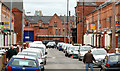
Sraid Rutland/Rutland Street in the Nationalist Lower Ormeau area
Image: © Eric Jones
Taken: 28 Mar 2017
0.03 miles
5
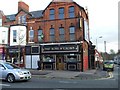
The Rose & Crown, Belfast
It is located along Ormeau Road
Image: © Kenneth Allen
Taken: 23 Nov 2009
0.03 miles
6
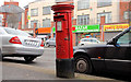
Pillar box, Belfast
A leaning EIIR pillar box, on the Ormeau Road, just outward of Rutland Street Image
Image: © Albert Bridge
Taken: 15 Mar 2011
0.04 miles
7
Balfour Avenue off Lower Ormeau Road
This is one of number of side streets between the Lower Ormeau Road and the River Lagan
Image: © Eric Jones
Taken: 10 Jul 2015
0.05 miles
8
Farnham Street off the Lower Ormeau Road
Image: © Eric Jones
Taken: 10 Jul 2015
0.06 miles
9
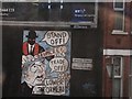
Nationalist/Republican Mural in Artana Street, Lower Ormeau Road
This is a mural, dating from 2002, in the Nationalist enclave of Lower Ormeau Road.
The CAIN Web Service - A Directory of Murals - Album 18
by Dr Jonathan McCormick describes the mural thus
"Stand off!" "Trade Off!" showing a sinister Orange Order figure brandishing a baseball bat labelled "Drumcree" over a Lower Ormeau resident. This is an older mural, previously covered by another mural.
http://cain.ulst.ac.uk/mccormick/album40.htm
Image: © Eric Jones
Taken: 19 Aug 2009
0.06 miles