IMAGES TAKEN NEAR TO
Dromara Street, BELFAST, BT7 2EZ
Introduction
This page details the photographs taken nearby to Dromara Street, BT7 2EZ by members of the Geograph project.
The Geograph project started in 2005 with the aim of publishing, organising and preserving representative images for every square kilometre of Great Britain, Ireland and the Isle of Man.

There are currently over 7.5m images from over14,400 individuals and you can help contribute to the project by visiting https://www.geograph.org.uk
Image Map
Images are licensed for reuse under creativecommons.org/licenses/by-sa/2.0
Notes
- Clicking on the map will re-center to the selected point.
- The higher the marker number, the further away the image location is from the centre of the postcode.
Image Listing (308 Images Found)
Images are licensed for reuse under creativecommons.org/licenses/by-sa/2.0
Image
Details
Distance
1
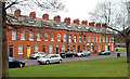
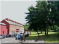
Dromara Street, Ormeau Road, Belfast
See Image Same Street – different viewpoint. Built in the early 20th century.
Image: © Albert Bridge
Taken: 23 Mar 2010
0.00 miles
2
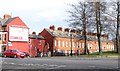
Dromara Street off Lower Ormeau Road
Dromara Street overlooks the River Lagan.
Image: © Eric Jones
Taken: 17 Feb 2015
0.00 miles
3
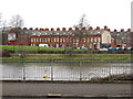
Dromara Street overlooking the River Lagan
Dromara Street lies off the Lower Ormeau Road.
Image: © Eric Jones
Taken: 17 Feb 2015
0.00 miles
4
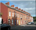
Dromara Street, Belfast
Short terraced street off the Ormeau Road. Close to the Ormeau Bridge the street has only developed along the northern side - the houses face onto the River Lagan opposite.
Image: © Rossographer
Taken: 1 Oct 2009
0.01 miles
5

Mural, Dromara Street
Mural on a gable wall on Dromara Street Image in Belfast.
I can't find much information about the mural but it seems to use pictures donated by members of the local community.
Image: © Rossographer
Taken: 1 Oct 2009
0.01 miles
6
Dromara Street off the Lower Ormeau Road
Image: © Eric Jones
Taken: 10 Jul 2015
0.01 miles
7
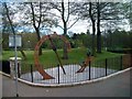
Public art work in Dromara Street, off the Lower Ormeau Road
This piece of sculpture inscribed in Irish is based on a 9thC Gaelic poem "The Blackbird of Belfast Lough".
"Int én bec
ro léic feit
do rind guip
glanbuidi
fo-ceird faíd
os Loch Laíg
lon do craíb
charnbuidi"
http://www.theguardian.com/books/booksblog/2008/nov/19/seamus-heaney-poetry-blackbird
Image: © Eric Jones
Taken: 27 Apr 2012
0.02 miles
8
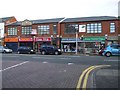
Section of the Ormeau Road, Belfast
It is located near the Stranmillis Embankment
Image: © Kenneth Allen
Taken: 23 Nov 2009
0.02 miles
9
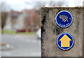
"Ulster Way" sign, Belfast
An “Ulster Way” waymark at the Ormeau bridge end of the Laganside Walkway. This is also part of National Cycle route no 9 Image
Image: © Albert Bridge
Taken: 27 Feb 2010
0.02 miles
10
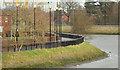
The Lagan Walkway, Belfast - 2014
The Lagan Walkway http://www.geograph.org.uk/search.php?i=46660410 approaching the Ormeau Road on its way from the Albert Bridge and the gasworks. Pedestrians can continue their riverside walk to Lisburn using the Stranmillis Embankment and the towpath.
Image: © Albert Bridge
Taken: 27 Jan 2014
0.02 miles