IMAGES TAKEN NEAR TO
Balfour Avenue, BELFAST, BT7 2EW
Introduction
This page details the photographs taken nearby to Balfour Avenue, BT7 2EW by members of the Geograph project.
The Geograph project started in 2005 with the aim of publishing, organising and preserving representative images for every square kilometre of Great Britain, Ireland and the Isle of Man.

There are currently over 7.5m images from over14,400 individuals and you can help contribute to the project by visiting https://www.geograph.org.uk
Image Map
Images are licensed for reuse under creativecommons.org/licenses/by-sa/2.0
Notes
- Clicking on the map will re-center to the selected point.
- The higher the marker number, the further away the image location is from the centre of the postcode.
Image Listing (315 Images Found)
Images are licensed for reuse under creativecommons.org/licenses/by-sa/2.0
Image
Details
Distance
1
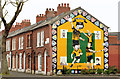
Hurling mural, Belfast
A St Malachy’s Gaelic Athletic Club mural at the corner of Balfour Avenue/ Ascaill Bhaile Phúir (left) and Shaftesbury Avenue/ Ascaill Shaftesbury Image
Image: © Albert Bridge
Taken: 27 Apr 2014
0.05 miles
2
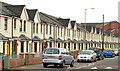
Shaftesbury Avenue, Belfast (April 2014)
Recent social housing, on the southern side of Shaftesbury Avenue, seen from Balfour Avenue. Building had just started when this Image was taken in November 2010.
Image: © Albert Bridge
Taken: 27 Apr 2014
0.05 miles
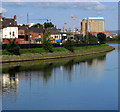
3
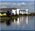
The River Lagan near the former gasworks, Belfast
River Lagan approaching the former gasworks site in Belfast. A call centre (white), one of the new buildings on the site, is seen in the distance (see Image).
Image: © Rossographer
Taken: 23 Sep 2008
0.08 miles
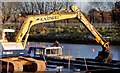
4
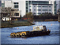
Barge 'Beachley' at Belfast
The barge 'Beachley' http://www.geograph.org.uk/search.php?i=17148176 heading upstream on the River Lagan. The barge is part of the force currently involved in dredging the river.
Image: © Rossographer
Taken: 23 Nov 2010
0.09 miles
5
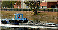
Dredging the River Lagan, Belfast - 2010/11 (39)
The “Cranagh Star”, downstream of the Ormeau Bridge, heading towards Queen’s Quay, pushing a barge loaded with dredged silt.
Image: © Albert Bridge
Taken: 25 Oct 2010
0.09 miles
6
The River Lagan at Ormeau Embankment
Another view of the River Lagan at Ormeau Embankment in Belfast. Houses at the lower Ormeau area are on the left; in the distance the BT Tower at Lanyon Place is clearly seen Image
Image: © Rossographer
Taken: 23 Sep 2008
0.10 miles
7
Dredging the River Lagan, Belfast - 2010/11 (76)
Another bucket load of silt being removed from the Lagan. This site is between the Cromac Lock and the Ormeau Bridge – close to Balfour Avenue Image
Image: © Albert Bridge
Taken: 30 Nov 2010
0.10 miles
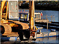
8
Dredging the River Lagan, Belfast - 2010/11 (77)
Another bucket load of silt Image going into the “Beachley” Image (right). This site is between the Cromac Lock and the Ormeau Bridge – close to Balfour Avenue Image
Image: © Albert Bridge
Taken: 30 Nov 2010
0.10 miles
9
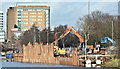
Revetment works, River Lagan, Belfast - February 2018(1)
The cofferdam seen from the Ormeau Embankment.
Image: © Albert Bridge
Taken: 12 Feb 2018
0.10 miles
10
Ormeau Health Centre, Belfast
It is located along the Ormeau Road
Image: © Kenneth Allen
Taken: 23 Nov 2009
0.10 miles