IMAGES TAKEN NEAR TO
McAuley Street, BELFAST, BT7 2BN
Introduction
This page details the photographs taken nearby to McAuley Street, BT7 2BN by members of the Geograph project.
The Geograph project started in 2005 with the aim of publishing, organising and preserving representative images for every square kilometre of Great Britain, Ireland and the Isle of Man.

There are currently over 7.5m images from over14,400 individuals and you can help contribute to the project by visiting https://www.geograph.org.uk
Image Map
Images are licensed for reuse under creativecommons.org/licenses/by-sa/2.0
Notes
- Clicking on the map will re-center to the selected point.
- The higher the marker number, the further away the image location is from the centre of the postcode.
Image Listing (434 Images Found)
Images are licensed for reuse under creativecommons.org/licenses/by-sa/2.0
Image
Details
Distance
1
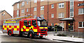
Fire appliance, Belfast
Attending to what turned out to be a false alarm in McAuley Street.
Image: © Albert Bridge
Taken: 22 Jan 2011
0.04 miles
3
Vacant site, The Markets, Belfast
Vacant ground between Cromac Street, the Gasworks and Raphael/McAuley Streets (background). It was one of the sites used for access underground during the recent rebuilding of Belfast’s sewers Image
Image: © Albert Bridge
Taken: 24 Sep 2010
0.06 miles
4
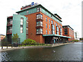
The Gasworks pond, Belfast
The pond, outside the hotel, with the fountain Image at the far end.
Image: © Albert Bridge
Taken: 23 May 2010
0.06 miles
5
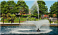
The Gasworks fountain, Belfast
The former Gasworks site (now called Cromac Wood) includes this fountain, at the Cromac Street end of a pond Image
Image: © Albert Bridge
Taken: 23 May 2010
0.07 miles
6
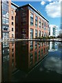
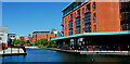
The redeveloped Belfast gasworks site
The Belfast gasworks was built between 1887 & 1893 and supplied the city with mains coal gas until it ceased production in 1988. The derelict site was subsequently taken over by the Laganside Corporation and was officially opened again in 2001. As well as accommodating various company offices - one of which is seen here reflected in the large dumbell-shaped water feature - it is now a public space where office workers and the general public can sit and have lunch it also provides access to the new riverside path along the Lagan. Few people who use this space are aware that the Blackstaff River, which rises in the Belfast hills, flowed through the city and entered the River Lagan through the gasworks, is still flowing beneath the water feature through a large underground culvert.
Image: © Robert Ashby
Taken: 15 Oct 2012
0.07 miles
7
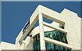
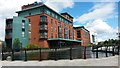
Halifax call centre, Belfast
The Halifax call centre (seen in Image) opened in 2002. Designed by MAP Architects, it is one of the most outstanding pieces of recent architecture in Belfast. This is part of the SW corner of the building. It looks especially well in the May sunshine against a cloudless sky.
Image: © Albert Bridge
Taken: 13 May 2008
0.07 miles
8
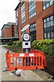
National Cycle Network milepost, Belfast (3)
Image: © Albert Bridge
Taken: 14 Mar 2011
0.07 miles
10
Bike hire
Belfast Bikes docking station being installed at the Gasworks business park.Taking its cue from similar schemes such as London's Boris Bikes, Dublin Bikes and those of other cities in the U.K. and Europe, Belfast has joined in.
Image: © Robert Ashby
Taken: 13 Apr 2015
0.08 miles