IMAGES TAKEN NEAR TO
Pakenham Mews, BELFAST, BT7 1XA
Introduction
This page details the photographs taken nearby to Pakenham Mews, BT7 1XA by members of the Geograph project.
The Geograph project started in 2005 with the aim of publishing, organising and preserving representative images for every square kilometre of Great Britain, Ireland and the Isle of Man.

There are currently over 7.5m images from over14,400 individuals and you can help contribute to the project by visiting https://www.geograph.org.uk
Image Map
Images are licensed for reuse under creativecommons.org/licenses/by-sa/2.0
Notes
- Clicking on the map will re-center to the selected point.
- The higher the marker number, the further away the image location is from the centre of the postcode.
Image Listing (1282 Images Found)
Images are licensed for reuse under creativecommons.org/licenses/by-sa/2.0
Image
Details
Distance
1
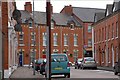
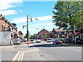
Pakenham Street, Belfast
Packenham Street is one of the few surviving red-brick traditional streets of terrace houses in central Belfast. The view is from the Dublin Road towards Donegall Pass.
Image: © Albert Bridge
Taken: 23 Sep 2007
0.01 miles
2
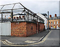
Air raid shelter, Belfast
The remains of a WW2 air raid shelter, one of only two still standing in central Belfast. It is sited at the corner of Pakenham Street and Donegall Pass and is now part of Donegall Pass PSNI station Image
Image: © Rossographer
Taken: 15 Mar 2010
0.01 miles
3
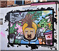
Street art, Donegall Pass, Belfast (October 2016)
Street art at the corner of Packenham Street and Donegall Pass. Painted by “Nozzle and Art” – a group which undertakes both commercial and social/community decoration.
Image: © Albert Bridge
Taken: 2 Oct 2016
0.02 miles
4
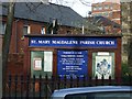
Noticeboard, St Mary Magdalene Church, Belfast
It is located here Image]
Image: © Kenneth Allen
Taken: 23 Nov 2009
0.03 miles
6
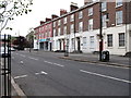
A terrace of shops and offices in Donegall Pass
Image: © Eric Jones
Taken: 19 May 2012
0.03 miles
7
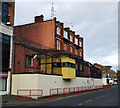
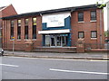
Donegall Pass PSNI station
Police Service of Northern Ireland station at Donegall Pass in Belfast. Not the prettiest of buildings, it appears to have begun in the old red brick building with various fortifications added over time (a common occurrence with police stations across Northern Ireland from the late 1960s onwards). It appears that there was, in 1980, a plan to replace the station with something more modern (see http://hansard.millbanksystems.com/written_answers/1980/may/09/donegall-pass-police-station ) but this never happened.
At the eastern end of the station, in the yard with the junction of Pakenham Street, is the remains of a WW2 air raid shelter - see Image
Image: © Rossographer
Taken: 15 Mar 2010
0.03 miles
8
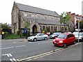
St Mary Magdalen CoI Church, Donegall Pass
This church was originally built in 1838 but was destroyed by fire in 1893 and subsequently rebuilt in 1900.
Image: © Eric Jones
Taken: 19 May 2012
0.04 miles
9
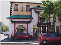
The Sun Kee Chinese Restaurant
The Donegall Pass area is the home Belfast's sizable Chinese Community.
Image: © Eric Jones
Taken: 30 Jun 2015
0.04 miles
10
Elim Pentecostal Church on the corner of Donegall Pass and Virginia Way
Elim Pentecostal Church was founded in Co Monaghan in 1915 by a Welshman, Pastor George Jeffreys of Nantyffylon, Maesteg. The denomination has a number of churches in Ulster, including in the city of Belfast.
Image: © Eric Jones
Taken: 19 May 2012
0.04 miles