IMAGES TAKEN NEAR TO
Rugby Avenue, BELFAST, BT7 1RG
Introduction
This page details the photographs taken nearby to Rugby Avenue, BT7 1RG by members of the Geograph project.
The Geograph project started in 2005 with the aim of publishing, organising and preserving representative images for every square kilometre of Great Britain, Ireland and the Isle of Man.

There are currently over 7.5m images from over14,400 individuals and you can help contribute to the project by visiting https://www.geograph.org.uk
Image Map
Images are licensed for reuse under creativecommons.org/licenses/by-sa/2.0
Notes
- Clicking on the map will re-center to the selected point.
- The higher the marker number, the further away the image location is from the centre of the postcode.
Image Listing (412 Images Found)
Images are licensed for reuse under creativecommons.org/licenses/by-sa/2.0
Image
Details
Distance
1
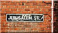
Street sign, Belfast
The not so common white-on-black street sign at the Rugby Avenue end of Jerusalem Street Image
Image: © Albert Bridge
Taken: 26 Aug 2009
0.01 miles
2
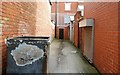
Short entry, Belfast
See Image A short entry – also off Carmel Street and not shown on the Google map.
Image: © Albert Bridge
Taken: 26 Aug 2009
0.06 miles
3
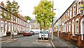
Cairo Street, Belfast
See Image Another of the streets in the “Holy Land”. The view is towards Rugby Avenue.
Image: © Albert Bridge
Taken: 26 Aug 2009
0.06 miles
4
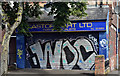
Graffiti, University Avenue, Belfast (August 2019)
Graffiti, on a shutter door, at 102 University Avenue (corner of Dudley Street). Note the old pre ”90” prefix telephone number.
Image: © Albert Bridge
Taken: 4 Aug 2019
0.06 miles
5
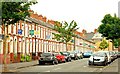
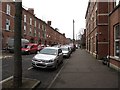
Carmel Street, Belfast (1)
See Image Carmel Street is another of the streets in the “Holy Land”. This is the western side seen from Agincourt Avenue Image looking towards Rugby Avenue. A classic Belfast street of red-brick terraced houses. See also Image and Image.
Image: © Albert Bridge
Taken: 16 Jun 2009
0.06 miles
7
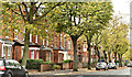
University Avenue, Belfast (October 2017)
A mainly Victorian Street running from Rugby Road to the Ormeau Road. This is the northern side from the corner of Carmel Street. Its history can be illustrated using old street directories.
1877 there was just one house “Rodgers, John, manager Henry Matier & Co [Henry Matier & Co., cambric handkerchief and linen manufacturers and merchants, 10 Waring Street]”.
1880 three houses “1. Rodgers, John, manager 2. Leitch, Matthew, professor of Biblical Criticism 3. Rodgers, Dr. John, professor of sacred rhetoric & catechetics [the branch of theology dealing with the instruction given to Christians before baptism or confirmation.]”.
1890 “Botanic Avenue to Caledonia Street no houses in this avenue”. Possibly some demolition work had taken place.
In 1901 some houses were still under construction but the completed and occupied odds numbered 65-141 and the evens 26-172.
Image: © Albert Bridge
Taken: 7 Oct 2017
0.07 miles
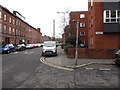
8
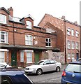
The junction of Carmel Street and Agincourt Avenue in the Queen's Quarter
The vast majority of these houses are multi-occupancy rooming houses for university students.
Image: © Eric Jones
Taken: 19 May 2012
0.07 miles
10
The Sandhurst Road junction on Fitzroy Avenue
Image: © Eric Jones
Taken: 17 Feb 2015
0.07 miles