IMAGES TAKEN NEAR TO
Carmel Street, BELFAST, BT7 1QE
Introduction
This page details the photographs taken nearby to Carmel Street, BT7 1QE by members of the Geograph project.
The Geograph project started in 2005 with the aim of publishing, organising and preserving representative images for every square kilometre of Great Britain, Ireland and the Isle of Man.

There are currently over 7.5m images from over14,400 individuals and you can help contribute to the project by visiting https://www.geograph.org.uk
Image Map
Images are licensed for reuse under creativecommons.org/licenses/by-sa/2.0
Notes
- Clicking on the map will re-center to the selected point.
- The higher the marker number, the further away the image location is from the centre of the postcode.
Image Listing (509 Images Found)
Images are licensed for reuse under creativecommons.org/licenses/by-sa/2.0
Image
Details
Distance
1
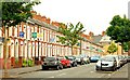
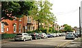
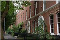
Carmel Street, Belfast (1)
See Image Carmel Street is another of the streets in the “Holy Land”. This is the western side seen from Agincourt Avenue Image looking towards Rugby Avenue. A classic Belfast street of red-brick terraced houses. See also Image and Image.
Image: © Albert Bridge
Taken: 16 Jun 2009
0.02 miles
2
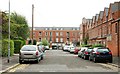
Rugby Parade, Belafst
A short, late 19th century, street running off Rugby Road Image The more recent Rugby Mews is in the background.
Image: © Albert Bridge
Taken: 4 Aug 2009
0.03 miles
3
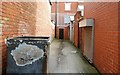
Short entry, Belfast
See Image A short entry – also off Carmel Street and not shown on the Google map.
Image: © Albert Bridge
Taken: 26 Aug 2009
0.04 miles
4
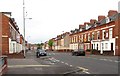
The junction of Carmel Street and Agincourt Avenue in the Queen's Quarter
The vast majority of these houses are multi-occupancy rooming houses for university students.
Image: © Eric Jones
Taken: 19 May 2012
0.05 miles
5
Rugby Street, Belfast
A short street, of substantial terrace houses, built around 1870. It runs off Rugby Road Image The more recent Rugby Mews is in the background.
Image: © Albert Bridge
Taken: 4 Aug 2009
0.05 miles
6
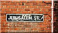
Street sign, Belfast
The not so common white-on-black street sign at the Rugby Avenue end of Jerusalem Street Image
Image: © Albert Bridge
Taken: 26 Aug 2009
0.07 miles
7
Southview Street, Belfast
Southview Street runs off Harrow Street Image but has a less complicated history. A street from the late 19th century with a few recent additions (out of picture to the left). The view is to Agincourt Avenue.
Image: © Albert Bridge
Taken: 1 Sep 2009
0.07 miles
8
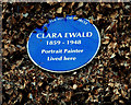
Clara Ewald plaque, Belfast
A plaque, on a house in Rugby Road, commemorating the painter Clara Ewald http://www.ulsterhistory.co.uk/clara%20ewald.html
Image: © Albert Bridge
Taken: 12 Dec 2009
0.08 miles
9
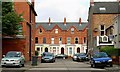
Rugby Road (part), Belfast
This part of Rugby Road, running from College Park to the back entrance to the Botanic Gardens, includes this substantial Victorian terrace. The view is towards Botanic Court. See also Image (June 2013).
Image: © Albert Bridge
Taken: 16 Jul 2007
0.08 miles
10
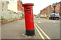
Victorian pillar box, Belfast (1)
An out-of-true VR pillar box, in Agincourt Avenue close to the corner of Rugby Road. The notice plate is missing. Continue to Image
Image: © Albert Bridge
Taken: 18 Jul 2009
0.08 miles