IMAGES TAKEN NEAR TO
Lawrence Street, BELFAST, BT7 1LF
Introduction
This page details the photographs taken nearby to Lawrence Street, BT7 1LF by members of the Geograph project.
The Geograph project started in 2005 with the aim of publishing, organising and preserving representative images for every square kilometre of Great Britain, Ireland and the Isle of Man.

There are currently over 7.5m images from over14,400 individuals and you can help contribute to the project by visiting https://www.geograph.org.uk
Image Map
Images are licensed for reuse under creativecommons.org/licenses/by-sa/2.0
Notes
- Clicking on the map will re-center to the selected point.
- The higher the marker number, the further away the image location is from the centre of the postcode.
Image Listing (638 Images Found)
Images are licensed for reuse under creativecommons.org/licenses/by-sa/2.0
Image
Details
Distance
1
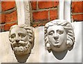
Doorway heads, Belfast (1)
The grander houses Image in what is now BT7 were occupied by the professional classes. The smaller houses to the east tended to be occupied by the skilled and clerical classes. Nevertheless they still display some interesting detail. These two heads are on nos 86 and 88 University Street. This end now has a mixture of multiple and owner occupation. Some have been converted to offices. See also Image
Image: © Albert Bridge
Taken: 12 Apr 2009
0.04 miles
2
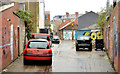
Entry, Belfast
A wide and wet entry off Lawrence Street.
Image: © Albert Bridge
Taken: 2 Oct 2013
0.04 miles
3
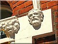
Doorway heads, Belfast (2)
Image: © Albert Bridge
Taken: 12 Apr 2009
0.04 miles
4
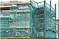
No 53 Cromwell Road, Belfast (May 2016)
See Image The new wall on the Lawrence Street side (left) with the retained Cromwell Road façade on the right. Both are well hidden behind the mesh.
Image: © Albert Bridge
Taken: 8 May 2016
0.04 miles
5
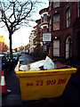
Skip, University Street
Helpfully placed skip blocking most of the pavement on University Street in Belfast.
Image: © Rossographer
Taken: 26 Jan 2009
0.04 miles
6
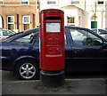
Postbox, Belfast
Elizabeth II postbox on University Street in Belfast.
Image: © Rossographer
Taken: 9 Mar 2010
0.04 miles
7
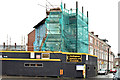
No 53 Cromwell Road, Belfast - November 2015(1)
An end-of-terrace house, at the corner of Lawrence Street (left), probably built around 1877/80, now being redeveloped as housing association flats. The Cromwell Road façade is being retained – everything else will be new. The relevant planning permission is “Z/2014/1103/F 53 Cromwell Road Botanic Avenue Belfast BT7 1JX Proposed extension and conversion of existing building to 9 no. 1 person 1 bedroom apartments.” Image shows the view from Lawrence Street. Continue to Image
Image: © Albert Bridge
Taken: 15 Nov 2015
0.05 miles
8
No 53 Cromwell Road, Belfast - November 2015(2)
See Image The view from Lawrence Street showing the retained Cromwell Road façade.
Image: © Albert Bridge
Taken: 15 Nov 2015
0.05 miles
9

Bench Mark, Belfast
Cut bench mark on a wall on University Street, Belfast, at the corner of Eblana Street. Damaged, it is not recorded on the 2007 OSNI maps but does feature on 1970s editions.
The mark is 10.02 metres above MSL.
See also http://www.geograph.org.uk/search.php?i=11037856 for many other examples I have found.
Image: © Rossographer
Taken: 22 Mar 2010
0.05 miles
10
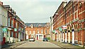
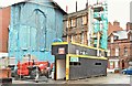
Eblana Street, Belfast
Part of bed-sit land, Eblana Street runs from University Street to the Cromwell Road (background).
Image: © Albert Bridge
Taken: 19 Apr 2009
0.05 miles