IMAGES TAKEN NEAR TO
Fitzroy Avenue, BELFAST, BT7 1HX
Introduction
This page details the photographs taken nearby to Fitzroy Avenue, BT7 1HX by members of the Geograph project.
The Geograph project started in 2005 with the aim of publishing, organising and preserving representative images for every square kilometre of Great Britain, Ireland and the Isle of Man.

There are currently over 7.5m images from over14,400 individuals and you can help contribute to the project by visiting https://www.geograph.org.uk
Image Map (Loading...)


Getting Data...Please wait
Leaflet Map data © OpenStreetMap
Images are licensed for reuse under creativecommons.org/licenses/by-sa/2.0
Notes
- Clicking on the map will re-center to the selected point.
- The higher the marker number, the further away the image location is from the centre of the postcode.
Image Listing (457 Images Found)
Images are licensed for reuse under creativecommons.org/licenses/by-sa/2.0
Image
Details
Distance
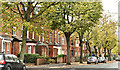
2
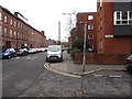
The Sandhurst Road junction on Fitzroy Avenue
Image: © Eric Jones
Taken: 17 Feb 2015
0.01 miles
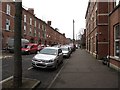
4
View north along Sandhurst Road
This links Fitzroy Avenue and University Street. The street junction on the left is that of Magdala Street.
Image: © Eric Jones
Taken: 17 Feb 2015
0.03 miles
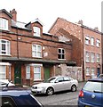
5
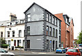
No1 Sandhurst Road, Belfast
See Image (June 2009) and Image (September 2009). For the record – the building after renovation and conversion to (rented) apartments.
Image: © Albert Bridge
Taken: 1 Sep 2013
0.03 miles
6
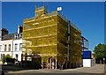
Building under renovation, Belfast
See Image The building seen in the previous photo is now being renovated (behind the mesh) and extended. Image (September 2013) shows the building after renovation and conversion to apartments.
Image: © Albert Bridge
Taken: 13 Sep 2009
0.04 miles
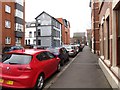
7
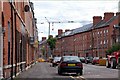
Fitzroy Avenue, Belfast
Fitzroy Avenue runs from Rugby Road to the Ormeau Road. Like many of the streets in the area (for example Image) it is very much bed-sit land. The view is towards the Ormeau Road.
Image: © Albert Bridge
Taken: 12 Aug 2007
0.04 miles
8
Magdala Street, Belfast (December 2018)
Image: © Albert Bridge
Taken: 30 Dec 2018
0.04 miles
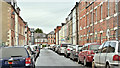
9
University Avenue, Belfast (October 2017)
A mainly Victorian Street running from Rugby Road to the Ormeau Road. This is the northern side from the corner of Carmel Street. Its history can be illustrated using old street directories.
1877 there was just one house “Rodgers, John, manager Henry Matier & Co [Henry Matier & Co., cambric handkerchief and linen manufacturers and merchants, 10 Waring Street]”.
1880 three houses “1. Rodgers, John, manager 2. Leitch, Matthew, professor of Biblical Criticism 3. Rodgers, Dr. John, professor of sacred rhetoric & catechetics [the branch of theology dealing with the instruction given to Christians before baptism or confirmation.]”.
1890 “Botanic Avenue to Caledonia Street no houses in this avenue”. Possibly some demolition work had taken place.
In 1901 some houses were still under construction but the completed and occupied odds numbered 65-141 and the evens 26-172.
Image: © Albert Bridge
Taken: 7 Oct 2017
0.04 miles
10
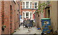
Back entry, Belfast
The eastern end of a back entry on the western side of Sandhurst Road (background).
Image: © Albert Bridge
Taken: 2 Oct 2013
0.05 miles