IMAGES TAKEN NEAR TO
University Street, BELFAST, BT7 1HR
Introduction
This page details the photographs taken nearby to University Street, BT7 1HR by members of the Geograph project.
The Geograph project started in 2005 with the aim of publishing, organising and preserving representative images for every square kilometre of Great Britain, Ireland and the Isle of Man.

There are currently over 7.5m images from over14,400 individuals and you can help contribute to the project by visiting https://www.geograph.org.uk
Image Map
Images are licensed for reuse under creativecommons.org/licenses/by-sa/2.0
Notes
- Clicking on the map will re-center to the selected point.
- The higher the marker number, the further away the image location is from the centre of the postcode.
Image Listing (322 Images Found)
Images are licensed for reuse under creativecommons.org/licenses/by-sa/2.0
Image
Details
Distance
1
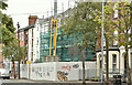
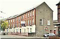
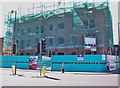
Nos 159-163 University Street, Belfast (July 2018)
A new building under construction on a previously-vacant site. The only planning permission I can find is this one from 14 August 2008 “Z/2006/2658/F Demolition of existing garage, store and adjacent terraced property at No.163 and erection of 16 No. 1 bedroom apartments. 159-163 University Street, Belfast, BT07 1HR”.
Image: © Albert Bridge
Taken: 22 Jul 2018
0.01 miles
2

Nos 124-126, University Street, Belfast (March 2014)
Two vacant and boarded-up houses towards the Ormeau Road end of University Street. Continue to Image
Image: © Albert Bridge
Taken: 2 Mar 2014
0.01 miles
3
Nos 124-126 University Street, Belfast (November 2017)
See Image Now under renovation.
Image: © Albert Bridge
Taken: 11 Nov 2017
0.02 miles
4
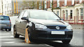
Clamped car, Belfast (November 2017)
A clamped car, possibly in relation to road tax, at University Street.
Image: © Albert Bridge
Taken: 11 Nov 2017
0.02 miles
5
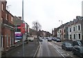
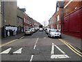
University Street, Belfast
As the name suggests, this road runs westwards towards the Queen's University campus.
Image: © Eric Jones
Taken: 15 Feb 2012
0.02 miles
6
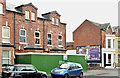
Nos 145 - 153 University Street, Belfast (July 2018)
Part of a terrace, at the corner of Dudley Street, now offered for sale. The agents’ description includes “Unique Opportunity to acquire 5 adjoining terrace properties. Excellent Re-development Potential ( subject to planning). Currently in use as Hostel 36 beds with additional office accommodation. Site Area: 0.15 acres, ( 0.06 Hecatres [sic])”.
I have no connection with the property and cannot enter into correspondence.
Image: © Albert Bridge
Taken: 22 Jul 2018
0.03 miles
7
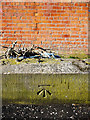
Bench Mark, Belfast
Cut bench mark on a low wall at University Street in Belfast.
The mark is 7.82 metres above MSL.
See also http://www.geograph.org.uk/search.php?i=11037856 for many other examples I have found.
Image: © Rossographer
Taken: 22 Mar 2010
0.03 miles
8
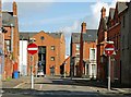
Dudley Street, Belfast
Dudley Street runs from Rugby Avenue, across University Avenue and Fitzroy Avenue, to University Street (background).
Image: © Albert Bridge
Taken: 22 Aug 2009
0.03 miles
9
Fitzroy Avenue off the Lower Ormeau Road
Image: © Eric Jones
Taken: 28 Mar 2017
0.03 miles
10
Social housing apartments under construction on the Lower Ormeau Road
This is a scheme by the Northern Ireland Housing Executive to provide 15 social housing apartments.
Image: © Eric Jones
Taken: 30 Jun 2015
0.03 miles