IMAGES TAKEN NEAR TO
Walnut Mews, BELFAST, BT7 1EZ
Introduction
This page details the photographs taken nearby to Walnut Mews, BT7 1EZ by members of the Geograph project.
The Geograph project started in 2005 with the aim of publishing, organising and preserving representative images for every square kilometre of Great Britain, Ireland and the Isle of Man.

There are currently over 7.5m images from over14,400 individuals and you can help contribute to the project by visiting https://www.geograph.org.uk
Image Map
Images are licensed for reuse under creativecommons.org/licenses/by-sa/2.0
Notes
- Clicking on the map will re-center to the selected point.
- The higher the marker number, the further away the image location is from the centre of the postcode.
Image Listing (458 Images Found)
Images are licensed for reuse under creativecommons.org/licenses/by-sa/2.0
Image
Details
Distance
1
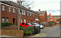
Pine Way, Belfast
Pine Street was built circa 1870 and ran from Donegall Pass to Vernon Street. After redevelopment it exists only at the Donegall Pass end. Pine Way is on the same line but is no longer a through street for vehicles. The view is in the direction of Donegall Pass.
Image: © Albert Bridge
Taken: 17 Feb 2010
0.04 miles
2
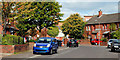
Walnut Street, Belfast
Part of the redeveloped area off Vernon Street Image The original Walnut Street (circa 1870), off Donegall Pass, was a bit shorter. Today’s follows the same line but cuts across the site of Lake and Outram Streets.
Image: © Albert Bridge
Taken: 24 Sep 2010
0.05 miles
3
"A" Company UVF Memorial in Walnut Street, off Donegall Pass
This is a memorial to members of "A" Company UVF Donegall Pass lost during "The Troubles". Donegall Pass was a stronghold of the UVF in contrast with the rest of the Protestant part of Donegall Road and the Sandy Row area where the UDA held sway. UVF stands for Ulster Volunteer Force and UDA for Ulster Defence Association.
http://cain.ulst.ac.uk/victims/memorials/static/photos/1521.html
Image: © Eric Jones
Taken: 30 Jun 2015
0.06 miles
4
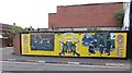
The Donegall Pass Memorial to men of the 36th Ulster Division
This mural is situated on the corner of Elm Street off Donegall Pass.
http://www.1914-1918.net/36div.htm
Image: © Eric Jones
Taken: 30 Jun 2015
0.06 miles
5
Young Citizen Volunteers Mural in Walnut Street, off Donegall Pass
Although dating back to 1912, the present YCV is a product of The Troubles when it was reformed as the youth wing of the paramilitary UVF.
http://en.wikipedia.org/wiki/Young_Citizen_Volunteers
Image: © Eric Jones
Taken: 19 May 2012
0.07 miles
6
![Loyalist Mural, Donegall Pass, Belfast [1]](https://s1.geograph.org.uk/photos/76/81/768193_bbd8e142_120x120.jpg)
Loyalist Mural, Donegall Pass, Belfast [1]
On the side of 'The Hideout' bar, this mural featuring a lone piper commemorates members of the local 'battalion' of the Ulster Volunteer Force who were killed during the 'Troubles'.
Image: © Rossographer
Taken: 18 Apr 2008
0.07 miles
7
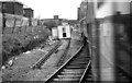
Slewed track near Belfast Central
The 14.10 Central – Londonderry leaving a temporarily singled stretch of line between the Ormeau Road bridge (background) and Central. Extensive work was underway on the formation.
Image: © Albert Bridge
Taken: 10 Mar 1984
0.07 miles
8
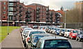
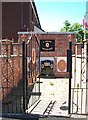
McClure Street, Belfast
See Image The same street, at the Ormeau Road end, showing the free all-day parking (used by non-residents).
Image: © Albert Bridge
Taken: 12 Feb 2010
0.07 miles
9
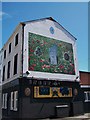
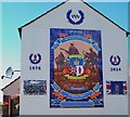
Ulster Tower Thiepval Memorial Mural off Donegall Pass
This mural is a memorial to the 32,286 men of the 36th Ulster Division who gave their lives on the Western Front. The mural has as its centrepiece a depiction of the Ulster Tower at Thiepval, France. That tower is a copy of a tower on the Clandeboye Estate in Co Down where the 36th Division were mobilized in 1914. The mural is painted on to the gable end of The Hideout PH. It replaces an earlier mural photographed by Rossographer.
Image]
https://www.youtube.com/watch?v=6C7CvYLcxaU
Image: © Eric Jones
Taken: 30 Jun 2015
0.08 miles
10
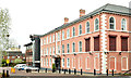
Havelock House, Belfast - May 2018(1)
The Havelock Street side of Havelock House. The building, extended in 1993 (left), was originally James Thompson & Sons (Belfast) Ltd, linen and cambric handkerchief manufacturers.
Havelock Street (Havelock Place on the Google map), now abandoned as a public street, includes part of the site of Havelock Cottage shown, in the 1880 street directory, occupied by Samuel Johnston, whitesmith https://en.oxforddictionaries.com/definition/whitesmith.
Old maps show that the street was on (or very close to) the site of Cromac Lodge (believed to have been built around 1780 when the area was mainly undeveloped countryside).
Image: © Albert Bridge
Taken: 6 May 2018
0.08 miles