IMAGES TAKEN NEAR TO
Salisbury Street, BELFAST, BT7 1AH
Introduction
This page details the photographs taken nearby to Salisbury Street, BT7 1AH by members of the Geograph project.
The Geograph project started in 2005 with the aim of publishing, organising and preserving representative images for every square kilometre of Great Britain, Ireland and the Isle of Man.

There are currently over 7.5m images from over14,400 individuals and you can help contribute to the project by visiting https://www.geograph.org.uk
Image Map
Images are licensed for reuse under creativecommons.org/licenses/by-sa/2.0
Notes
- Clicking on the map will re-center to the selected point.
- The higher the marker number, the further away the image location is from the centre of the postcode.
Image Listing (1465 Images Found)
Images are licensed for reuse under creativecommons.org/licenses/by-sa/2.0
Image
Details
Distance
1
Salisbury Court, Belfast
Salisbury Court (between Salisbury Street and Hartington Street) off the Dublin Road was built in the 80’s (as part of a larger scheme) replacing old small terraced houses.
Image: © Albert Bridge
Taken: 23 Sep 2007
0.02 miles
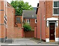
2
Salisbury Lane, Belfast
An entry running off Salisbury Street Image It becomes Ashburne (“Ashbourne” on the Google map) Place once round the corner on the right.
Image: © Albert Bridge
Taken: 9 Jun 2009
0.04 miles
3
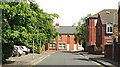
Salisbury Street, Belfast
The area to the east of the Dublin Road saw widespread redevelopment in the 1980’s. Salisbury Street (foreground) and Maryville Street were rebuilt on the sites of the old streets. There is greenery now where there was none before.
Image: © Albert Bridge
Taken: 9 Jun 2009
0.04 miles
4
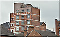
Somerset Studios, Belfast (June 2017)
Somerset Studios seen from Bankmore Street. The building is not listed but is officially described as “The former Somerset and Co Ltd Linen Factory was converted into loft apartments in 1998. This building was surveyed in the First Survey but not listed. A partial record only was taken during the Second Survey as the building is not worthy of a full survey.” Previously seen in October 2007 Image
I have no connection with the building and cannot enter into correspondence.
Image: © Albert Bridge
Taken: 11 Jun 2017
0.04 miles
5
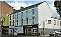
Nos 52 - 54 Dublin Road, Belfast - September 2019(1)
At present the proposed redevelopment is just that with no advance public consultation announced though an impression, of the completed building, is available here http://www.futurebelfast.com/property/52-54-dublin-road/. Salisbury Street is on the right.
Image: © Albert Bridge
Taken: 1 Sep 2019
0.04 miles
6
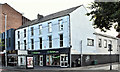
Nos 50-54 Dublin Road, Belfast (September 2016)
Two buildings, almost opposite Ventry Street and close to the corner of Salisbury Street. No 50 is a Thai restaurant. Nos 52/54 are occupied by an Oxfam furniture shop.
Image: © Albert Bridge
Taken: 4 Sep 2016
0.05 miles
7
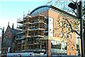
Nos 74 & 76 Dublin Road, Belfast (6)
See Image Now looking as if it’s close to completion. The scaffolding hides what will be a mainly glass frontage to the Dublin Road. Continue to Image
Image: © Albert Bridge
Taken: 30 Nov 2008
0.05 miles
8
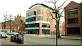
Nos 74&76 Dublin Road, Belfast (7)
See Image Although not, perhaps, formally complete the appearance of the building is fairly close to its final form. Image shows the one it replaced. Image shows the estate agent’s impression of this one. Image shows the building when occupied.
Image: © Albert Bridge
Taken: 8 Feb 2009
0.05 miles
9
Entry, Belfast
Entry, running behind Pakenham Street Image, off the Dublin Road
Image: © Albert Bridge
Taken: 22 Aug 2009
0.05 miles
10

Vacant buildings, Belfast
Empty buildings at the corner of the Dublin Road and Hartington Street (right). Subsequently demolished and replaced. The replacement building is now occupied by a Tesco Express Image
Image: © Albert Bridge
Taken: 6 Jul 1986
0.05 miles