IMAGES TAKEN NEAR TO
Derryfubble Road, DUNGANNON, BT71 7JS
Introduction
This page details the photographs taken nearby to Derryfubble Road, BT71 7JS by members of the Geograph project.
The Geograph project started in 2005 with the aim of publishing, organising and preserving representative images for every square kilometre of Great Britain, Ireland and the Isle of Man.

There are currently over 7.5m images from over14,400 individuals and you can help contribute to the project by visiting https://www.geograph.org.uk
Image Map
Images are licensed for reuse under creativecommons.org/licenses/by-sa/2.0
Notes
- Clicking on the map will re-center to the selected point.
- The higher the marker number, the further away the image location is from the centre of the postcode.
Image Listing (39 Images Found)
Images are licensed for reuse under creativecommons.org/licenses/by-sa/2.0
Image
Details
Distance
1
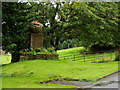
Large stone monument
On the drive to Servite Priory, Benburb.
Image: © HENRY CLARK
Taken: 18 Aug 2007
0.02 miles
3
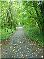
Benburb Valley Park
Taken close to Maydown Bridge
Image: © HENRY CLARK
Taken: 18 Aug 2007
0.02 miles
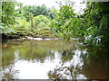
5
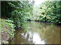
The River Blackwater
Close to Maydown Bridge looking west
Image: © HENRY CLARK
Taken: 18 Aug 2007
0.02 miles
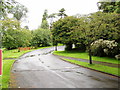
6
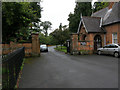
Entrance to Servite Priory, Benburb
View from Main Street.
Image: © Terry Stewart
Taken: 18 Aug 2007
0.02 miles
7
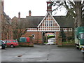
Servite Priory, Benburb
Part of the main courtyard and clock tower.
Image: © Brian Shaw
Taken: 15 Mar 2007
0.02 miles
8
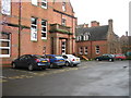
Servite Priory, Benburb.
This view shows the main entrance.
Image: © Brian Shaw
Taken: 15 Mar 2007
0.02 miles
9
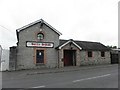
The Bottle of Benburb
It is located at Derryfubble Road
Image: © Kenneth Allen
Taken: 16 May 2011
0.09 miles
10
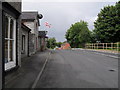
Derryfubble Road, Benburb
Looking towards Dungannon.
Image: © Dean Molyneaux
Taken: 26 Jul 2009
0.12 miles