IMAGES TAKEN NEAR TO
Lisbofin Road, DUNGANNON, BT71 7JH
Introduction
This page details the photographs taken nearby to Lisbofin Road, BT71 7JH by members of the Geograph project.
The Geograph project started in 2005 with the aim of publishing, organising and preserving representative images for every square kilometre of Great Britain, Ireland and the Isle of Man.

There are currently over 7.5m images from over14,400 individuals and you can help contribute to the project by visiting https://www.geograph.org.uk
Image Map
Images are licensed for reuse under creativecommons.org/licenses/by-sa/2.0
Notes
- Clicking on the map will re-center to the selected point.
- The higher the marker number, the further away the image location is from the centre of the postcode.
Image Listing (8 Images Found)
Images are licensed for reuse under creativecommons.org/licenses/by-sa/2.0
Image
Details
Distance
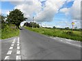
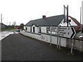
3
Crossroads - Mullanary Road and Lisbofin Road.
Derelict bus shelter in background.
Image: © Terry Stewart
Taken: 21 Aug 2007
0.20 miles
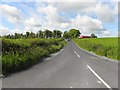
4
Lisbofin Road, Blackwatertown
Heading ESE towards Richhill / Loughgall
Image: © Kenneth Allen
Taken: 9 Jun 2011
0.21 miles
5
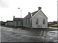
National School, Blackwatertown
It is located at the corner of Charlemont Road and Lisbofin Road
Image: © Kenneth Allen
Taken: 9 Jun 2011
0.22 miles
6
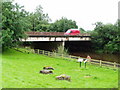
Blackwater Bridge
Taken from the car park in Blackwater Village
Image: © HENRY CLARK
Taken: 18 Aug 2007
0.22 miles
7
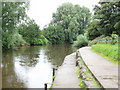
Blackwater River
Taken from a docking point close to the village
Image: © HENRY CLARK
Taken: 18 Aug 2007
0.22 miles