IMAGES TAKEN NEAR TO
Dreemore Road, DUNGANNON, BT71 7EL
Introduction
This page details the photographs taken nearby to Dreemore Road, BT71 7EL by members of the Geograph project.
The Geograph project started in 2005 with the aim of publishing, organising and preserving representative images for every square kilometre of Great Britain, Ireland and the Isle of Man.

There are currently over 7.5m images from over14,400 individuals and you can help contribute to the project by visiting https://www.geograph.org.uk
Image Map
Images are licensed for reuse under creativecommons.org/licenses/by-sa/2.0
Notes
- Clicking on the map will re-center to the selected point.
- The higher the marker number, the further away the image location is from the centre of the postcode.
Image Listing (4 Images Found)
Images are licensed for reuse under creativecommons.org/licenses/by-sa/2.0
Image
Details
Distance
1
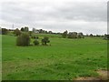
Land south of Laghy Corner
Most of the day was dull for pictures, but the greens came out fairly well
Image: © Kenneth Allen
Taken: 31 Oct 2007
0.06 miles
2
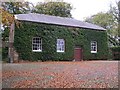
Grange Quaker Meeting house
Dates from 1660. This is the 'new meeting house'Image]
Image: © Kenneth Allen
Taken: 31 Oct 2007
0.16 miles
3
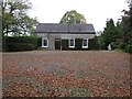
Grange old Quaker Meeting house
It is on the same site - This is the 'old meeting house' used for social events, etc nowadays. Neither it or the new one is the original building, Grange represented the furthest Quakers came west in Ireland.
Image: © Kenneth Allen
Taken: 31 Oct 2007
0.16 miles
4
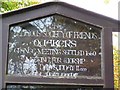
Plaque, Religious Society of Friends
The notice at the gate speaks of the Religious Society of Friends. The term 'Quaker' is used in many Quaker organisations but RSF is the official name and is short for Friends of the Truth, or even Friends of Jesus in the view of some.Image]
Image: © Kenneth Allen
Taken: 31 Oct 2007
0.16 miles