IMAGES TAKEN NEAR TO
Moy Road, DUNGANNON, BT71 7DS
Introduction
This page details the photographs taken nearby to Moy Road, BT71 7DS by members of the Geograph project.
The Geograph project started in 2005 with the aim of publishing, organising and preserving representative images for every square kilometre of Great Britain, Ireland and the Isle of Man.

There are currently over 7.5m images from over14,400 individuals and you can help contribute to the project by visiting https://www.geograph.org.uk
Image Map
Images are licensed for reuse under creativecommons.org/licenses/by-sa/2.0
Notes
- Clicking on the map will re-center to the selected point.
- The higher the marker number, the further away the image location is from the centre of the postcode.
Image Listing (23 Images Found)
Images are licensed for reuse under creativecommons.org/licenses/by-sa/2.0
Image
Details
Distance
1
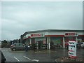
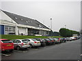
The Spar Ranfurly Service Station, Dungannon
This is a price winning Spar service station and shop on the south-east outskirts of Dungannon.
http://www.htec.co.uk/content/default.asp?PageId=258
Image: © Eric Jones
Taken: 19 Aug 2009
0.12 miles
2
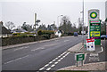
The Moy Road, Dungannon
The A29 Moy Road on the outskirts of Dunagannon at Ranfurly Service Station Image Unleaded petrol was selling at 109.9p per litre with diesel at 118.9p.
Image: © Rossographer
Taken: 14 Mar 2015
0.13 miles
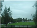
3
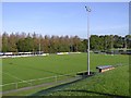
Dungannon Rugby Football Club
Looking north
Image: © Kenneth Allen
Taken: 10 Oct 2006
0.14 miles
4
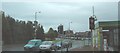
The junction of Gortmerron Link Road and Moy Road
The cars are waiting in the Gortmerron Link Road.
Image: © Eric Jones
Taken: 19 Aug 2009
0.14 miles
5
Dungannon Rugby Club
Looking back along the front of the clubhouse in a S/Westerly direction towards the entrance.
Image: © Willie Duffin
Taken: 31 Jan 2009
0.15 miles
6
The main pitch of the Dungannon Rugby Football ground in Moy Road
http://www.dungannonrugby.co.uk/
Image: © Eric Jones
Taken: 19 Aug 2009
0.15 miles
7
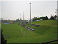
Dungannon Rugby Club
A view along the terraced spectator area above the pitch.This gives an excellent view of the game and is also pretty handy to the clubhouse for half-time refreshments.
Image: © Willie Duffin
Taken: 31 Jan 2009
0.16 miles
8
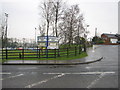
Stevenson Park home to Dungannon Rugby Club
The road leading to Stevenson Park which is the home ground of Dungannon Rugby Club.The main road in the foreground is the A29 Moy road.The entrance to the club is just before the bungalow on the left which is on Ranfurley Heights.
Image: © Willie Duffin
Taken: 31 Jan 2009
0.17 miles
9
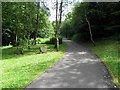
Path near the mill race, Dungannon
The path leads to The Linen Green at Moygashel
See close-up of plaque here Image]
Image: © Kenneth Allen
Taken: 6 Jul 2011
0.18 miles
10

Footbridge, Dungannon
The path heads north-east towards Dungannon Park
Image: © Kenneth Allen
Taken: 6 Jul 2011
0.19 miles