IMAGES TAKEN NEAR TO
Braeside, DUNGANNON, BT71 7BY
Introduction
This page details the photographs taken nearby to Braeside, BT71 7BY by members of the Geograph project.
The Geograph project started in 2005 with the aim of publishing, organising and preserving representative images for every square kilometre of Great Britain, Ireland and the Isle of Man.

There are currently over 7.5m images from over14,400 individuals and you can help contribute to the project by visiting https://www.geograph.org.uk
Image Map
Images are licensed for reuse under creativecommons.org/licenses/by-sa/2.0
Notes
- Clicking on the map will re-center to the selected point.
- The higher the marker number, the further away the image location is from the centre of the postcode.
Image Listing (6 Images Found)
Images are licensed for reuse under creativecommons.org/licenses/by-sa/2.0
Image
Details
Distance
1
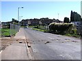
Lisnahull, Dungannon
This area is still being developed
Image: © Kenneth Allen
Taken: 16 Sep 2006
0.16 miles
2
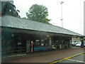
The booking office and waiting room at the Ulsterbus Depot at Dungannon
Image: © Eric Jones
Taken: 19 Aug 2009
0.23 miles
3
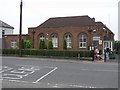
Northern Ireland Housing Executive, Dungannon
They are located on the Ballygawley Road
Image: © Kenneth Allen
Taken: 29 Aug 2008
0.23 miles
4
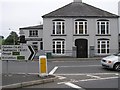
Holmes of Dungannon
This Funeral Director could be the last man to let you down.
Image: © Kenneth Allen
Taken: 29 Aug 2008
0.23 miles
5
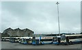
Buses waiting to be called to the boarding forecourt at Dungannon's Ulsterbus station
The Ulsterbus Station is located in Beechvale - an extension of Scotch Street.
Image: © Eric Jones
Taken: 19 Aug 2009
0.23 miles
6
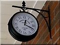
Paddington Station Clock London 1854
Pictured here Image]
Image: © Kenneth Allen
Taken: 21 Mar 2016
0.24 miles