IMAGES TAKEN NEAR TO
Railway Road, DUNGANNON, BT71 7AA
Introduction
This page details the photographs taken nearby to Railway Road, BT71 7AA by members of the Geograph project.
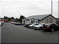
The Geograph project started in 2005 with the aim of publishing, organising and preserving representative images for every square kilometre of Great Britain, Ireland and the Isle of Man.

There are currently over 7.5m images from over14,400 individuals and you can help contribute to the project by visiting https://www.geograph.org.uk
Image Map
Images are licensed for reuse under creativecommons.org/licenses/by-sa/2.0
Notes
- Clicking on the map will re-center to the selected point.
- The higher the marker number, the further away the image location is from the centre of the postcode.
Image Listing (324 Images Found)
Images are licensed for reuse under creativecommons.org/licenses/by-sa/2.0
Image
Details
Distance
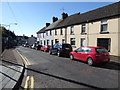
1
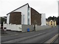
Dungannon Baptist Church
Looking north-east along Railway Road
In the background is the old yellow coloured dispensary with a plaque on the wall Image]
Image: © Kenneth Allen
Taken: 29 Feb 2012
0.01 miles
2
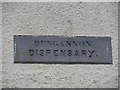
Plaque, Dungannon Dispensary
Viewed from here Image]
Image: © Kenneth Allen
Taken: 29 Feb 2012
0.01 miles
3
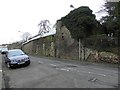
Old building, Dungannon
It looks historic, but I'm not sure what it is.
Image: © Kenneth Allen
Taken: 29 Feb 2012
0.02 miles
4
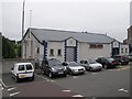
The Royal British Legion, Dungannon
It is located near the bottom of Scotch Street
Image: © Kenneth Allen
Taken: 29 Aug 2008
0.02 miles
5
Royal British Legion, Dungannon
Looking south-east
Image: © Kenneth Allen
Taken: 18 Jan 2012
0.04 miles
6
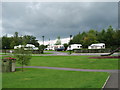
Caravan site in Dungannon Park
Found this lovely little caravan site by chance in Dungannon Park and found it to be very clean and tidy and well run.
Image: © Raymond McSherry
Taken: 19 Aug 2006
0.05 miles
7
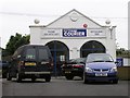
The Tyrone Courier Offices, Dungannon
They are located off Scotch Street more at http://www.mediauk.com/newspapers/21286/tyrone-courier
Image: © Kenneth Allen
Taken: 29 Aug 2008
0.05 miles
8
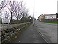
Railway Road, Dungannon
Heading WNW; Dungannon Railway Park is on the left - no more railways though!
Image: © Kenneth Allen
Taken: 29 Feb 2012
0.06 miles
9
Barrack Street, Dungannon
Looking south-east from Scotch Street
Image: © Kenneth Allen
Taken: 19 May 2017
0.07 miles
10
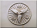
CTC plaque, Dungannon
It has been placed sideways (the left wing should be pointing upwards)
CTC stands for Cyclists' Touring Club formed in 1883. It started off as the Bicycle Touring Club in Harrogate in 1879. More at https://sites.google.com/site/squarewheelstouring/cycling-history
Pictured here Image]
Image: © Kenneth Allen
Taken: 21 Mar 2016
0.07 miles