IMAGES TAKEN NEAR TO
Castle Glen Ponds, DUNGANNON, BT71 6XX
Introduction
This page details the photographs taken nearby to Castle Glen Ponds, BT71 6XX by members of the Geograph project.
The Geograph project started in 2005 with the aim of publishing, organising and preserving representative images for every square kilometre of Great Britain, Ireland and the Isle of Man.

There are currently over 7.5m images from over14,400 individuals and you can help contribute to the project by visiting https://www.geograph.org.uk
Image Map
Images are licensed for reuse under creativecommons.org/licenses/by-sa/2.0
Notes
- Clicking on the map will re-center to the selected point.
- The higher the marker number, the further away the image location is from the centre of the postcode.
Image Listing (2 Images Found)
Images are licensed for reuse under creativecommons.org/licenses/by-sa/2.0
Image
Details
Distance
1
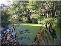
Parkland in Dungannon
When I first saw the flat green surface I thought that it was grass.
Image: © Kenneth Allen
Taken: 10 Oct 2006
0.06 miles
2
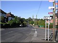
Dungannon
Looking towards the town from the south-east.
Image: © Kenneth Allen
Taken: 10 Oct 2006
0.24 miles