IMAGES TAKEN NEAR TO
College Lands Road, DUNGANNON, BT71 6SN
Introduction
This page details the photographs taken nearby to College Lands Road, BT71 6SN by members of the Geograph project.
The Geograph project started in 2005 with the aim of publishing, organising and preserving representative images for every square kilometre of Great Britain, Ireland and the Isle of Man.

There are currently over 7.5m images from over14,400 individuals and you can help contribute to the project by visiting https://www.geograph.org.uk
Image Map
Images are licensed for reuse under creativecommons.org/licenses/by-sa/2.0
Notes
- Clicking on the map will re-center to the selected point.
- The higher the marker number, the further away the image location is from the centre of the postcode.
Image Listing (7 Images Found)
Images are licensed for reuse under creativecommons.org/licenses/by-sa/2.0
Image
Details
Distance
1
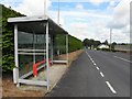
B28, College Lands Road
Heading north-west towards Charlemont and Moy
Image: © Kenneth Allen
Taken: 28 Jun 2011
0.04 miles
2
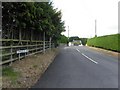
Corrigan Hill Road
Viewed from College Lands Road
My attention was drawn to the sign with the rosary beads Image]
Image: © Kenneth Allen
Taken: 28 Jun 2011
0.10 miles
3
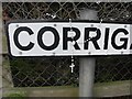
Rosary beads, Corrigans Hill Road
A parishioner has left them behind on the sign
Viewed here Image]
Image: © Kenneth Allen
Taken: 28 Jun 2011
0.11 miles
4
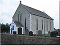
St Peter's Parish Church
Catholic church built in 1845.
Image: © Brian Shaw
Taken: 5 Jul 2006
0.11 miles
5
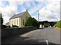
Collegeland RC Church
It is located along Corrigan Hill Road
Image: © Kenneth Allen
Taken: 28 Jun 2011
0.11 miles
6
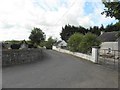
Corrigan Hill Road
The bend curves south
Image: © Kenneth Allen
Taken: 28 Jun 2011
0.12 miles
7
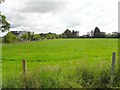
Keenaghan Townland
Looking north-east from College Lands Road
Image: © Kenneth Allen
Taken: 28 Jun 2011
0.14 miles