IMAGES TAKEN NEAR TO
Mullenakill Park, DUNGANNON, BT71 6PG
Introduction
This page details the photographs taken nearby to Mullenakill Park, BT71 6PG by members of the Geograph project.
The Geograph project started in 2005 with the aim of publishing, organising and preserving representative images for every square kilometre of Great Britain, Ireland and the Isle of Man.

There are currently over 7.5m images from over14,400 individuals and you can help contribute to the project by visiting https://www.geograph.org.uk
Image Map
Images are licensed for reuse under creativecommons.org/licenses/by-sa/2.0
Notes
- Clicking on the map will re-center to the selected point.
- The higher the marker number, the further away the image location is from the centre of the postcode.
Image Listing (2 Images Found)
Images are licensed for reuse under creativecommons.org/licenses/by-sa/2.0
Image
Details
Distance
1

The M1 near Verner's Bridge and Coalisland (1980)
The view towards Tamnamore and Dungannon from the bridge on the Derrylee Road. Verner’s Bridge Image is just about visible after the end of the trees on the right.
Image: © Albert Bridge
Taken: 5 Jul 1980
0.19 miles
2
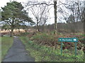
Peatlands Park
Peatlands Park was established in 1990 to raise awareness of peatland habitats and has been designated an Area of Special Scientific Interest. It was the first of its type in The British Isles and has over 10 miles of paths to help visitors explore the many varied habitats as well as a narrow gauge railway. The park contains many unique species of flora and fauna which can be found nowhere else in Northern Ireland.
Image: © Robert Ashby
Taken: 30 Jan 2013
0.20 miles