IMAGES TAKEN NEAR TO
Derrylee Road, DUNGANNON, BT71 6NU
Introduction
This page details the photographs taken nearby to Derrylee Road, BT71 6NU by members of the Geograph project.
The Geograph project started in 2005 with the aim of publishing, organising and preserving representative images for every square kilometre of Great Britain, Ireland and the Isle of Man.

There are currently over 7.5m images from over14,400 individuals and you can help contribute to the project by visiting https://www.geograph.org.uk
Image Map
Images are licensed for reuse under creativecommons.org/licenses/by-sa/2.0
Notes
- Clicking on the map will re-center to the selected point.
- The higher the marker number, the further away the image location is from the centre of the postcode.
Image Listing (4 Images Found)
Images are licensed for reuse under creativecommons.org/licenses/by-sa/2.0
Image
Details
Distance
1
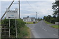
Derrylee Road
Can be Derrylee or Derrylea, take your pick.
Image: © Robert Ashby
Taken: 24 Jun 2015
0.15 miles
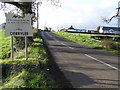
3
Cronkill
Heading north-east into Derrylee
Image: © Kenneth Allen
Taken: 14 Nov 2006
0.19 miles
4
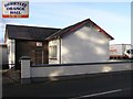
Derrylee Orange Hall
Located in Cronkill and it is to the west of Derrylee
Image: © Kenneth Allen
Taken: 14 Nov 2006
0.20 miles