IMAGES TAKEN NEAR TO
Clonmore Road, DUNGANNON, BT71 6HX
Introduction
This page details the photographs taken nearby to Clonmore Road, BT71 6HX by members of the Geograph project.
The Geograph project started in 2005 with the aim of publishing, organising and preserving representative images for every square kilometre of Great Britain, Ireland and the Isle of Man.

There are currently over 7.5m images from over14,400 individuals and you can help contribute to the project by visiting https://www.geograph.org.uk
Image Map
Images are licensed for reuse under creativecommons.org/licenses/by-sa/2.0
Notes
- Clicking on the map will re-center to the selected point.
- The higher the marker number, the further away the image location is from the centre of the postcode.
Image Listing (5 Images Found)
Images are licensed for reuse under creativecommons.org/licenses/by-sa/2.0
Image
Details
Distance
3
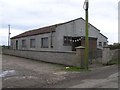
Clonmore AOH Hall
The buntings seem to indicate that this hall is still used.
Image: © Kenneth Allen
Taken: 31 Oct 2007
0.17 miles
4
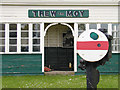
Trew and Moy Railway shelter
There is still a timetable pasted on the wall inside, but no evidence of the railway track.
More on the Trew and Moy station at http://en.wikipedia.org/wiki/Trew_and_Moy_railway_station
Image: © Kenneth Allen
Taken: 2 May 2003
0.19 miles
5
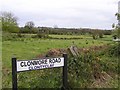
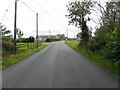
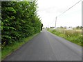
View from Clonmore Road
Looking north-east
Image: © Kenneth Allen
Taken: 31 Oct 2007
0.21 miles