IMAGES TAKEN NEAR TO
Tamnamore Road, DUNGANNON, BT71 6HW
Introduction
This page details the photographs taken nearby to Tamnamore Road, BT71 6HW by members of the Geograph project.
The Geograph project started in 2005 with the aim of publishing, organising and preserving representative images for every square kilometre of Great Britain, Ireland and the Isle of Man.

There are currently over 7.5m images from over14,400 individuals and you can help contribute to the project by visiting https://www.geograph.org.uk
Image Map
Images are licensed for reuse under creativecommons.org/licenses/by-sa/2.0
Notes
- Clicking on the map will re-center to the selected point.
- The higher the marker number, the further away the image location is from the centre of the postcode.
Image Listing (9 Images Found)
Images are licensed for reuse under creativecommons.org/licenses/by-sa/2.0
Image
Details
Distance
1
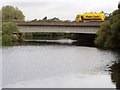
A Motorway Bridge close to J14 on the M1
Taken from the jetty at Verner's Bridge
Image: © HENRY CLARK
Taken: 22 Sep 2007
0.02 miles
2
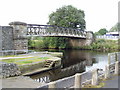
Verner's Bridge
Verners Bridge crosses the River Blackwater, the county border between Co. Armagh and Co.Tyrone
Image: © HENRY CLARK
Taken: 22 Sep 2007
0.04 miles
4
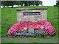
Tamnamore
This flower arrangement brightens a dull day.
Image: © Brian Shaw
Taken: 13 Sep 2006
0.07 miles
7
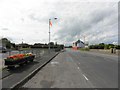
B106, Tamnamore
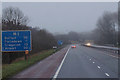
Heading WNW and parallel to the M1
Image: © Kenneth Allen
Taken: 1 Aug 2011
0.22 miles
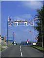
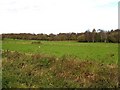
8
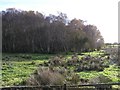
Annaghbeg Townland
Looking south-east
Image: © Kenneth Allen
Taken: 14 Nov 2006
0.23 miles