IMAGES TAKEN NEAR TO
Moorville, DUNGANNON, BT71 5ND
Introduction
This page details the photographs taken nearby to Moorville, BT71 5ND by members of the Geograph project.
The Geograph project started in 2005 with the aim of publishing, organising and preserving representative images for every square kilometre of Great Britain, Ireland and the Isle of Man.

There are currently over 7.5m images from over14,400 individuals and you can help contribute to the project by visiting https://www.geograph.org.uk
Image Map
Images are licensed for reuse under creativecommons.org/licenses/by-sa/2.0
Notes
- Clicking on the map will re-center to the selected point.
- The higher the marker number, the further away the image location is from the centre of the postcode.
Image Listing (1 Images Found)
Images are licensed for reuse under creativecommons.org/licenses/by-sa/2.0
Image
Details
Distance
1
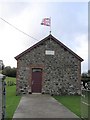
Enniskillen Orange Hall
I was speaking to a local and was wondering why Enniskillen Orange Hall was located here. I thought that it should be in County Fermanagh but he said that in fact the hall was not quite where it should be anyway as the townland of Enniskillen was several miles away. The plaque denotes that it was erected in 1919.
This is the hall in Enniskillen town in County Fermanagh Image]
Image: © Kenneth Allen
Taken: 31 Oct 2006
0.23 miles