IMAGES TAKEN NEAR TO
Killycolpy Road, DUNGANNON, BT71 5AH
Introduction
This page details the photographs taken nearby to Killycolpy Road, BT71 5AH by members of the Geograph project.
The Geograph project started in 2005 with the aim of publishing, organising and preserving representative images for every square kilometre of Great Britain, Ireland and the Isle of Man.

There are currently over 7.5m images from over14,400 individuals and you can help contribute to the project by visiting https://www.geograph.org.uk
Image Map
Images are licensed for reuse under creativecommons.org/licenses/by-sa/2.0
Notes
- Clicking on the map will re-center to the selected point.
- The higher the marker number, the further away the image location is from the centre of the postcode.
Image Listing (2 Images Found)
Images are licensed for reuse under creativecommons.org/licenses/by-sa/2.0
Image
Details
Distance
1
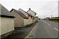
Killycolpy Road
Not sure if this is still a functioning pub or not. Has a deserted air about it.
Image: © Robert Ashby
Taken: 23 Mar 2016
0.04 miles
2
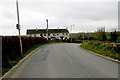
A bit of a puzzle
This bit of Mountjoy Road is almost on the intersection of four adjacent squares, H 9071, 9171, 9170 & 9070 and passes through all four on a short S-bend. I was only just in H 9071 and the terrace of houses in front is bisected diagonally by the southern edge of 9171, the front of the left hand end being in 9171 and the rear of the right in 9170. Just round the bend the road passes briefly through the north-west corner of 9170 before entering 9070 and heading SW. I didn't deliberately pick this spot to make life more interesting for the moderator, just happened to stop here by chance, and have no GPS other than the one in my camera which I can't read until I upload the pictures anyway.
Image: © Robert Ashby
Taken: 23 Mar 2016
0.13 miles