IMAGES TAKEN NEAR TO
Laurel Grove, DUNGANNON, BT71 4SA
Introduction
This page details the photographs taken nearby to Laurel Grove, BT71 4SA by members of the Geograph project.
The Geograph project started in 2005 with the aim of publishing, organising and preserving representative images for every square kilometre of Great Britain, Ireland and the Isle of Man.

There are currently over 7.5m images from over14,400 individuals and you can help contribute to the project by visiting https://www.geograph.org.uk
Image Map
Images are licensed for reuse under creativecommons.org/licenses/by-sa/2.0
Notes
- Clicking on the map will re-center to the selected point.
- The higher the marker number, the further away the image location is from the centre of the postcode.
Image Listing (5 Images Found)
Images are licensed for reuse under creativecommons.org/licenses/by-sa/2.0
Image
Details
Distance
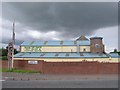
1
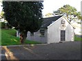
Newtownkelly Methodist Church, Coalisland
It is on the south side of the town
Image: © Kenneth Allen
Taken: 6 Nov 2006
0.06 miles
2
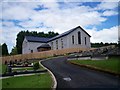
Brackaville Holy Trinity Church Hall, Coalisland
Image: © P Flannagan
Taken: 30 Jul 2008
0.15 miles
3
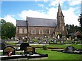
Brackaville Holy Trinity Parish Church, Coalisland
Image: © P Flannagan
Taken: 30 Jul 2008
0.16 miles
4
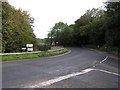
Coalisland Road
It is in the townland of Derry
Image: © Kenneth Allen
Taken: 10 Oct 2006
0.22 miles
5
Island Turf Crafts
They are located at Dungannon Road, Coalisland
Image: © Kenneth Allen
Taken: 24 Jul 2009
0.25 miles