IMAGES TAKEN NEAR TO
Lancedean Road, BELFAST, BT6 9QP
Introduction
This page details the photographs taken nearby to Lancedean Road, BT6 9QP by members of the Geograph project.
The Geograph project started in 2005 with the aim of publishing, organising and preserving representative images for every square kilometre of Great Britain, Ireland and the Isle of Man.

There are currently over 7.5m images from over14,400 individuals and you can help contribute to the project by visiting https://www.geograph.org.uk
Image Map
Images are licensed for reuse under creativecommons.org/licenses/by-sa/2.0
Notes
- Clicking on the map will re-center to the selected point.
- The higher the marker number, the further away the image location is from the centre of the postcode.
Image Listing (31 Images Found)
Images are licensed for reuse under creativecommons.org/licenses/by-sa/2.0
Image
Details
Distance
1
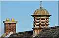
Chimneys and lantern, Cregagh, Belfast
Chimneys and lantern on the hall of St Finian's (CoI) parish church Image The buildings are below the level of the Upper Knockbreda Road making this one of the few places where it’s possible to photograph a lantern without converging verticals.
Image: © Albert Bridge
Taken: 1 Nov 2012
0.11 miles
2
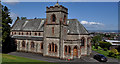
St Finian's (CoI) parish church, Belfast
Church of Ireland between Cregagh Park and the Upper Knockbreda Road. Designed by WD&RT Taggart who also designed Image Both date from the early 1930’s. It has a good view (middle right) over east Belfast.
Image: © Albert Bridge
Taken: 24 May 2011
0.12 miles
3
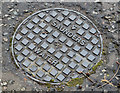
Saunders access cover, Belfast (February 2016)
A plastic Saunders access cover, in the footpath, on the Upper Knockbreda Road, close to the entrance to Cregagh Glen. I don’t know whether the name refers to the manufacturer or a wholesaler.
Image: © Albert Bridge
Taken: 22 Feb 2016
0.12 miles
4
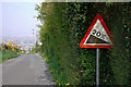
The Rocky Road, Belfast
Minor road running from the Manse Road to the Upper Knockbreda Road / outer ring road in east Belfast. This is the view approaching Knockbreda when it suddenly descends with a 1 in 5 drop and several sharp bends. Best to test the brakes first and avoid altogether in icy conditions (the road is prone to being closed if the weather is particularly severe). See also Image Central Belfast can be glimpsed through the haze.
Image: © Rossographer
Taken: 20 Apr 2011
0.13 miles
5
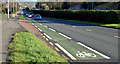
Cycle lane, Cregagh, Belfast - February 2016(1)
A cycle lane, between the Cregagh Road and Rochester Road, on the dual carriageway Upper Knockbreda Road – part of the Belfast outer ring road. See also Image
Image: © Albert Bridge
Taken: 22 Feb 2016
0.13 miles
6
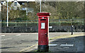
Pillar box (BT6 738), Cregagh, Belfast (February 2016)
EIIR pillar box (BT6 738) at the Rochester Road end of Stirling Avenue.
Image: © Albert Bridge
Taken: 22 Feb 2016
0.14 miles
7
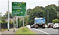
Route confirmatory sign, Upper Knockbreda Road, Belfast (September 2015)
A route confirmatory sign, for westbound traffic, on the Upper Knockbreda Road dual carriageway, past the junction with the Cregagh Road. The road is part of the Belfast outer ring.
Image: © Albert Bridge
Taken: 9 Sep 2015
0.14 miles
8
The Upper Knockbreda Road, Belfast
The dual carriageway (left) is part of the Cregagh (background) to Knock section of the Belfast outer ring road Image and Image It opened in 1967 replacing the old road on the right.
Image: © Albert Bridge
Taken: 24 May 2011
0.14 miles
9
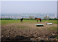
Horses near Belfast
A field and two horses off the Rocky Road above east Belfast. The city can be glimpsed through the haze, although on a clear day much more would be visible.
Image: © Rossographer
Taken: 20 Apr 2011
0.17 miles
10
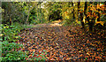
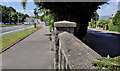
Path, Cregagh Glen, Belfast (1)
The path, covered today by very wet leaves, close to the entrance on the Upper Knockbreda Road. The Cregagh River is hidden on the left.
Image: © Albert Bridge
Taken: 1 Nov 2012
0.18 miles