IMAGES TAKEN NEAR TO
Hillburn Park, BELFAST, BT6 9PF
Introduction
This page details the photographs taken nearby to Hillburn Park, BT6 9PF by members of the Geograph project.
The Geograph project started in 2005 with the aim of publishing, organising and preserving representative images for every square kilometre of Great Britain, Ireland and the Isle of Man.

There are currently over 7.5m images from over14,400 individuals and you can help contribute to the project by visiting https://www.geograph.org.uk
Image Map
Images are licensed for reuse under creativecommons.org/licenses/by-sa/2.0
Notes
- Clicking on the map will re-center to the selected point.
- The higher the marker number, the further away the image location is from the centre of the postcode.
Image Listing (9 Images Found)
Images are licensed for reuse under creativecommons.org/licenses/by-sa/2.0
Image
Details
Distance
1
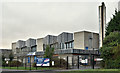
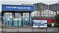
The Robinson Centre, Belfast - January 2017(4)
The Montgomery Road side of the building seen from the north west.
Image: © Albert Bridge
Taken: 15 Jan 2017
0.16 miles
2
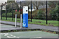
E-car charging point, Montgomery Road, Belfast (January 2017)
An e-car charging point, close to the Robinson Centre Image, on the Montgomery Road.
Image: © Albert Bridge
Taken: 15 Jan 2017
0.16 miles
3
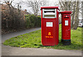
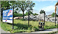
Postboxes, Belfast
Large postbox for franked mail (BT6 421) and George VI pillar box (BT6 719) on Montgomery Road, Belfast.
Image: © Rossographer
Taken: 20 Mar 2017
0.17 miles
4
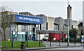
The Robinson Centre, Belfast - January 2017(1)
The Montgomery Road side of the building seen from the north east.
Image: © Albert Bridge
Taken: 15 Jan 2017
0.18 miles
5
The Robinson Centre, Belfast - January 2017(2)
The former front (Montgomery Road) entrance.
Image: © Albert Bridge
Taken: 15 Jan 2017
0.18 miles
6
The Robinson Centre (demolition), Belfast (June 2017)
Now demolished.
Image: © Albert Bridge
Taken: 18 Jun 2017
0.18 miles
7
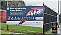
The Robinson Centre, Belfast - January 2017(3)
A sign, on the perimeter fence, announcing the new aquatics centre.
Image: © Albert Bridge
Taken: 15 Jan 2017
0.19 miles
8
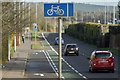
Cycle lane, Cregagh, Belfast - February 2016(2)
See Image The same cycle lane as it approaches the Rochester Road/Tudor Drive turn.
Image: © Albert Bridge
Taken: 22 Feb 2016
0.20 miles
9

Winter blossom, Belfast
Irrespective of the season, this berry tree is in full colour.
Located to the rear of houses on Stirling Avenue and Tudor Drive in the Lisnasharragh area of Castlereagh, in south-east Belfast.
Image: © Dean Molyneaux
Taken: 6 Dec 2009
0.22 miles