IMAGES TAKEN NEAR TO
Somme Drive, BELFAST, BT6 9JJ
Introduction
This page details the photographs taken nearby to Somme Drive, BT6 9JJ by members of the Geograph project.
The Geograph project started in 2005 with the aim of publishing, organising and preserving representative images for every square kilometre of Great Britain, Ireland and the Isle of Man.

There are currently over 7.5m images from over14,400 individuals and you can help contribute to the project by visiting https://www.geograph.org.uk
Image Map
Images are licensed for reuse under creativecommons.org/licenses/by-sa/2.0
Notes
- Clicking on the map will re-center to the selected point.
- The higher the marker number, the further away the image location is from the centre of the postcode.
Image Listing (23 Images Found)
Images are licensed for reuse under creativecommons.org/licenses/by-sa/2.0
Image
Details
Distance
1

Downshire Park Central, Belfast - September 2015(1)
Housing with green space and trees, on the eastern side of the Cregagh Road. See also Image
Image: © Albert Bridge
Taken: 9 Sep 2015
0.08 miles
2
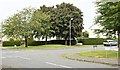
Downshire Park Central, Belfast - September 2015(2)
See Image Downshire Park Central (running from left to right) seen from Downshire Park South. To the best of my knowledge the area was built in the 1950’s when houses had proper space around and between them and landscaping was taken seriously.
Image: © Albert Bridge
Taken: 9 Sep 2015
0.08 miles
3
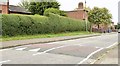
Road humps, Cregagh, Belfast (September 2015)
Traffic-calming road humps at the Cregagh Road end of The Straight Image – something not needed or even envisaged when the road and estate were built in the 1950’s.
Image: © Albert Bridge
Taken: 9 Sep 2015
0.08 miles
4
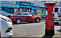
Pillar box, Belfast
GVIR pillar box, on the Cregagh Road, near Downshire Park Central.
Image: © Albert Bridge
Taken: 24 May 2011
0.11 miles
5

The Straight, Cregagh, Belfast (September 2015)
See Image Rippingham design at its best. Flat-roofed red-brick houses, in the Cregagh estate, built in the 1950’s. The road is still surfaced with concrete.
Image: © Albert Bridge
Taken: 9 Sep 2015
0.12 miles
6
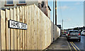
Hamel Drive, Cregagh Road, Belfast (January 2017)
A street, on the eastern side of the Cregagh Road, two streets to the north of Somme Drive. The name probably comes from the WW1 battle (1916) at Beaumont Hamel http://www.ww1battlefields.co.uk/somme/beaumont.html although there was also a battle at Hamel in 1918 http://www.historynet.com/world-war-i-battle-of-hamel.htm.
Image: © Albert Bridge
Taken: 9 Jan 2017
0.13 miles
7

Schomberg House
Headquarters of The Grand Orange Lodge of Ireland.
The building comprises office accommodation, an Orange memorabilia shop, library and research facilities, a conference room and a Cultural Heritage Centre.
Image: © Brian Shaw
Taken: 18 Jan 2006
0.13 miles
8

Lisnasharragh Secondary School
This pile of rubble is all that is left of Lisnasharragh Secondary School, photo taken on Tudor Drive looking towards Merok Park
Image: © AINTREE IRON
Taken: 31 Mar 2014
0.13 miles
9
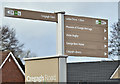
Pedestrian direction signs, Cregagh Road, Belfast (January 2017)
Signs, at the lay-by close to Cregagh Park, giving directions to local places of interest.
Image: © Albert Bridge
Taken: 9 Jan 2017
0.16 miles
10

McFadzean VC plaque, Belfast
Self-explanatory memorial plaque on what is now a dental surgery, at the corner of Cregagh Park and the Cregagh Road, in memory of Billy McFadzean VC. The citation reads “No. 14/18278 Pte. William Frederick McFadzean, late R. Ir. Rif. For most conspicuous bravery. While in a concentration trench and opening a box of bombs for distribution prior to an attack, the box slipped down into the trench, which was crowded with men, and two of the safety pins fell out. Private McFadzean, instantly realising the danger to his comrades, with heroic courage threw himself on the top of the Bombs. The bombs exploded blowing him to pieces, but only one other man was injured. He well knew his danger, being himself a bomber, but without a moment's hesitation he gave his life for his comrades”.
Image shows the blue plaque erected, on the Cregagh Road side of the same building, in 2016.
Image: © Albert Bridge
Taken: 24 May 2011
0.18 miles