IMAGES TAKEN NEAR TO
Montgomery Chase, BELFAST, BT6 9GQ
Introduction
This page details the photographs taken nearby to Montgomery Chase, BT6 9GQ by members of the Geograph project.
The Geograph project started in 2005 with the aim of publishing, organising and preserving representative images for every square kilometre of Great Britain, Ireland and the Isle of Man.

There are currently over 7.5m images from over14,400 individuals and you can help contribute to the project by visiting https://www.geograph.org.uk
Image Map
Images are licensed for reuse under creativecommons.org/licenses/by-sa/2.0
Notes
- Clicking on the map will re-center to the selected point.
- The higher the marker number, the further away the image location is from the centre of the postcode.
Image Listing (19 Images Found)
Images are licensed for reuse under creativecommons.org/licenses/by-sa/2.0
Image
Details
Distance
1
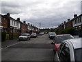
Mayfair Avenue, Cregagh
Mayfair Avenue is a busy street as it's often used as a shortcut between Montgomery Road and the Cregagh Road.
Image: © Dean Molyneaux
Taken: 9 Jul 2009
0.14 miles
2
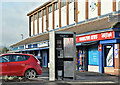
Telephone box, Cregagh Road, Belfast (January 2017)
A KX300 telephone box, at these shops Image, on the Cregagh Road.
Image: © Albert Bridge
Taken: 9 Jan 2017
0.15 miles
3
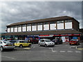
Greenway, Cregagh Road
This row of shops is known as Greenway, sited just off the Cregagh Road and at the main entrance to the estate.
Image: © Dean Molyneaux
Taken: 9 Jul 2009
0.16 miles
4
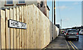
Hamel Drive, Cregagh Road, Belfast (January 2017)
A street, on the eastern side of the Cregagh Road, two streets to the north of Somme Drive. The name probably comes from the WW1 battle (1916) at Beaumont Hamel http://www.ww1battlefields.co.uk/somme/beaumont.html although there was also a battle at Hamel in 1918 http://www.historynet.com/world-war-i-battle-of-hamel.htm.
Image: © Albert Bridge
Taken: 9 Jan 2017
0.16 miles
5
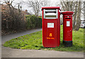
Postboxes, Belfast
Large postbox for franked mail (BT6 421) and George VI pillar box (BT6 719) on Montgomery Road, Belfast.
Image: © Rossographer
Taken: 20 Mar 2017
0.17 miles
6
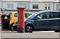
Pillar box, Cregagh, Belfast
GR pillar box (BT6 251) outside Cregagh post office, Greenway Image
Image: © Albert Bridge
Taken: 24 Jul 2013
0.17 miles
7
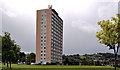
Kilbroney House, Belfast (2)
See Image Kilbroney House, from the north at the North Bank, showing it, in the open green space popular at time, towering over the traditionally-sized terraces. Continue to Image (July 2013).
Image: © Albert Bridge
Taken: 24 May 2011
0.19 miles
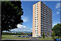
8
Kilbroney House, Belfast (1)
Way back in the days of rationing, after WWII, TPO Rippingham Image designed the Cregagh housing estate in rows of flat-roofed two-storey terraces. Some 17 years later the Northern Ireland Housing Trust came along with the fifteen storeys of Kilbroney House by which time tower blocks were about to go out of fashion.
Approximate contemporary of Seymour Hill Image, Rushpark Image and Belvoir Image the Cregagh block is not so well known.
This view is from the north east, near the back of the shops and shows the side of the building facing the Cregagh Road. Image shows the building from a different viewpoint.
Image: © Albert Bridge
Taken: 24 May 2011
0.19 miles
9
Kilbroney House, Belfast (3)
See Image (May 2011). The eastern side of Kilbroney House seen from Kilbroney Bend.
Image: © Albert Bridge
Taken: 24 Jul 2013
0.21 miles
10
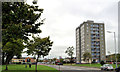
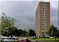
Willowbrook House, Belfast
See Image An eleven-storey block of flats, at Killagan Bend, in the Cregagh estate. Built (exact date unknown) in the 1950’s the block is one of three in the estate. This is the western side seen from Mount Merrion Avenue. Previously seen, 5½ years ago in Image
Image: © Albert Bridge
Taken: 10 Aug 2011
0.21 miles