IMAGES TAKEN NEAR TO
Loopland Gardens, BELFAST, BT6 9EB
Introduction
This page details the photographs taken nearby to Loopland Gardens, BT6 9EB by members of the Geograph project.
The Geograph project started in 2005 with the aim of publishing, organising and preserving representative images for every square kilometre of Great Britain, Ireland and the Isle of Man.

There are currently over 7.5m images from over14,400 individuals and you can help contribute to the project by visiting https://www.geograph.org.uk
Image Map
Images are licensed for reuse under creativecommons.org/licenses/by-sa/2.0
Notes
- Clicking on the map will re-center to the selected point.
- The higher the marker number, the further away the image location is from the centre of the postcode.
Image Listing (44 Images Found)
Images are licensed for reuse under creativecommons.org/licenses/by-sa/2.0
Image
Details
Distance
1

Cat, Belfast
Domestic cat looking over a high fence as seen from the Connswater Greenway Image
Image: © Rossographer
Taken: 16 Jan 2023
0.09 miles
2
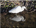
Little Egret, Belfast
Little Egret on the Loop River in Belfast as seen from above on the Connswater Greenway Image
Image: © Rossographer
Taken: 16 Jan 2023
0.09 miles
3
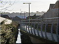
The Connswater Greenway, Belfast
The Greenway alongside the Loop River between the Castlereagh Road and Ladas Drive. Cycling, I had stopped after spotting the unmistakable blue flash of a Kingfisher skimming along the water.
Image: © Rossographer
Taken: 12 Oct 2018
0.10 miles
4
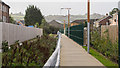
The Connswater Greenway, Belfast
The Greenway alongside the Loop River between the Castlereagh Road and Ladas Drive. Here you can see the clever design of this part of the path which is raised and overhangs the river, allowing wildlife to flourish and humans to pass above. Kingfishers and Egrets are regularly seen here Image
Image: © Rossographer
Taken: 16 Jan 2023
0.11 miles
5
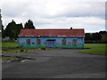
Loopriver Play Centre, Ladas Way
This rather forlorn looking structure is a Belfast City Council maintained play centre on Daddy Winker's Lane - or Ladas Way. A full explanation can be found here: Image
Image: © Dean Molyneaux
Taken: 9 Jul 2009
0.11 miles
6
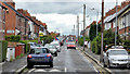
Loopland Park, Belfast
A narrow street, built after WW1, running from the Cregagh Road (background) to the Castlereagh Road and sometimes used as a shortcut between them.
Image: © Albert Bridge
Taken: 15 Jul 2011
0.13 miles
7
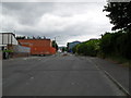
Daddy Winker's Lane - Ladas Way (2)
This shows the barricade that separates Gibson Park Avenue and Ladas Way, collectively known as Daddy Winker's Lane. See: Image The road is blocked to prevent motorists using it as a shortcut between the Cregagh Road and Ladas Drive.
Image: © Dean Molyneaux
Taken: 9 Jul 2009
0.13 miles
8
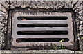
Needham grating cover, Belfast
Image: © Albert Bridge
Taken: 10 Aug 2011
0.15 miles
9
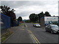
Daddy Winker's Lane - Ladas Way
This is Ladas Way off Ladas Drive. Locally this has always been known as 'Daddy Winker's Lane'. Having done some research online, the only explanation I've found is that a Mr. Wilson, who once owned the land here had large bushy eyebrows. The area was developed between the 1930s and 1950s. There was once a pond to the left of the image - now under a government office.
Image: © Dean Molyneaux
Taken: 9 Jul 2009
0.15 miles
10
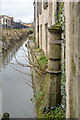
Boundary Post, Belfast
Old parliamentary boundary post overhanging the Loop River behind Ladas Drive in Belfast. See also Image
The inscription reads:
"Parliamentary
and Municipal Boundary of
Belfast
Ormeau Division
Ormeau Ward
1918".
Image: © Rossographer
Taken: 6 Dec 2018
0.15 miles