IMAGES TAKEN NEAR TO
Woodstock Road, BELFAST, BT6 9DP
Introduction
This page details the photographs taken nearby to Woodstock Road, BT6 9DP by members of the Geograph project.
The Geograph project started in 2005 with the aim of publishing, organising and preserving representative images for every square kilometre of Great Britain, Ireland and the Isle of Man.

There are currently over 7.5m images from over14,400 individuals and you can help contribute to the project by visiting https://www.geograph.org.uk
Image Map
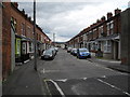
Images are licensed for reuse under creativecommons.org/licenses/by-sa/2.0
Notes
- Clicking on the map will re-center to the selected point.
- The higher the marker number, the further away the image location is from the centre of the postcode.
Image Listing (64 Images Found)
Images are licensed for reuse under creativecommons.org/licenses/by-sa/2.0
Image
Details
Distance
1
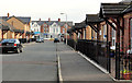
Omeath Street
Omeath Street off the Woodstock Road. Like Greenore Street - it is named after a County Louth village.
Image: © Dean Molyneaux
Taken: 9 Jul 2009
0.03 miles
2
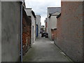
Entry between Greenore Street and Omeath Street
The entry between Greenore Street and Omeath Street off the Woodstock Road.
Image: © Dean Molyneaux
Taken: 9 Jul 2009
0.04 miles
3
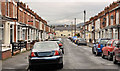
Greenore Street
Greenore Street off the Woodstock Road. Its title presumably comes from the County Louth port of the same name.
Image: © Dean Molyneaux
Taken: 9 Jul 2009
0.05 miles
4
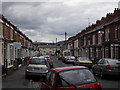
Greenore Street, Belfast
A street, dating from the late 19th century, running from The Woodstock Road to Carlingford Street (background). It still retains the original terrace houses. Previously seen in Image (July 2009).
Image: © Albert Bridge
Taken: 26 Apr 2012
0.06 miles
5
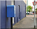
Drop box, Belfast
A blue drop box at the Woodstock Road end of Killowen Street.
Image: © Albert Bridge
Taken: 26 Apr 2012
0.08 miles
6
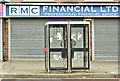
Telephone boxes, Woodstock Road, Belfast (April 2018)
Two KX100 telephone boxes outside 281/283 Woodstock Road.
Image: © Albert Bridge
Taken: 13 Apr 2018
0.09 miles
7
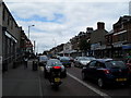
Woodstock Road
The Woodstock at the Northern Bank.
Image: © Dean Molyneaux
Taken: 9 Jul 2009
0.09 miles
8
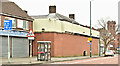
Former Willowfield police station, Belfast - April 2018(1)
The Woodstock Road side. The wall hides most of the building.
Image: © Albert Bridge
Taken: 13 Apr 2018
0.10 miles
9
Newry Street, Belfast
A street running from Euston Street to the Castlereagh Road (background). Built in the late 19th century and now rebuilt as shown.
Image: © Albert Bridge
Taken: 16 Nov 2011
0.10 miles
10
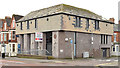
Former Danske (Northern) Bank, Woodstock Road, Belfast (March 2015)
The former Northern (later Danske) Bank, at 381-385 Woodstock Road (corner of Ogilvie Street), was another one culled in the wake of the banking catastrophe. Now offered for sale and described by the agents as “The property comprises a large, end terraced, former bank premises extending over two floors. Built in the early 1980s the building is of masonry construction with a mansard style roof incorporating hanging tile cladding on all elevations at first floor level.” This photograph appears as a matter of record only. I have no connection with any of the parties involved in the sale.
Image: © Albert Bridge
Taken: 1 Mar 2015
0.11 miles