1
Decorated shutter door, Belfast
Decorated shutter door, on premises formerly occupied by part of the “social economy”, at Isthmus Street
Image off the Woodstock Road.
Image: © Albert Bridge
Taken: 22 Dec 2011
0.01 miles
2
Isthmus Street sign, Belfast
The original Isthmus Street was a late Victorian creation of 15 houses. Now redeveloped, there are no houses at the Woodstock Road end so the name sign is mounted on posts.
Image: © Albert Bridge
Taken: 22 Dec 2011
0.01 miles
3
Nos 243-245 Woodstock Road, Belfast (May 2018)
The two former terrace houses. There are adjoining vacant sites which do not appear to be part of this offer.
Image: © Albert Bridge
Taken: 30 May 2018
0.02 miles
4
Pillar box, Belfast
EIIR pillar box on the Woodstock Road, close to My Lady’s Road.
Image: © Albert Bridge
Taken: 16 Nov 2011
0.03 miles
5
Vacant buildings, Willowfield, Belfast
Houses, converted to shops, now vacant and possibly awaiting redevelopment, at the corner of the Woodstock Road (foreground) and Willowfield Street.
Image: © Albert Bridge
Taken: 5 Nov 2013
0.03 miles
6
Willowfield war memorial, Belfast
Memorial, on the Woodstock Road, near Cherryville Street, in memory of local men who died in WW1.
Image: © Albert Bridge
Taken: 16 Nov 2011
0.04 miles
7
Decorated shutter door, Belfast - April 2014(1)
A decorated shutter door on the Woodstock Road.
Image: © Albert Bridge
Taken: 14 Apr 2014
0.04 miles
8
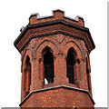
Willowfield (CoI) parish church, Belfast (1)
Willowfield (CoI) parish Church, at the corner of the Woodstock Road (foreground) and My Lady’s Road
Image Completed in 1872 to a design by John Lanyon of Lanyon, Lynn and Lanyon. Extended in 1901 by WJ Fennel.
Image shows the belfry.
Image: © Albert Bridge
Taken: 22 Dec 2011
0.05 miles
9
Willowfield (CoI) parish church, Belfast (2)
See
Image The belfry seen from My Lady’s Road
Image An early drawing shows a spire on top although it’s unclear whether it was an unexecuted design or an original feature later removed.
Image: © Albert Bridge
Taken: 22 Dec 2011
0.05 miles
10
Ravenhill Presbyterian Church
Built 1905.
Image: © Brian Shaw
Taken: 1 Nov 2005
0.05 miles


