IMAGES TAKEN NEAR TO
Curlagh Road, AUGHNACLOY, BT69 6JF
Introduction
This page details the photographs taken nearby to Curlagh Road, BT69 6JF by members of the Geograph project.
The Geograph project started in 2005 with the aim of publishing, organising and preserving representative images for every square kilometre of Great Britain, Ireland and the Isle of Man.

There are currently over 7.5m images from over14,400 individuals and you can help contribute to the project by visiting https://www.geograph.org.uk
Image Map
Images are licensed for reuse under creativecommons.org/licenses/by-sa/2.0
Notes
- Clicking on the map will re-center to the selected point.
- The higher the marker number, the further away the image location is from the centre of the postcode.
Image Listing (5 Images Found)
Images are licensed for reuse under creativecommons.org/licenses/by-sa/2.0
Image
Details
Distance
1
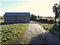
Hall at Curlagh
When I last pictured the hall it had chimney flues coming out of the roof Image]
Image: © Kenneth Allen
Taken: 4 Feb 2015
0.01 miles
2
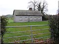
Hall at Curlagh
It has an impressive set of chimney flues.
When I pictured the hall again in Feb 2015, I noted that they were gone Image]
Image: © Kenneth Allen
Taken: 16 Nov 2007
0.02 miles
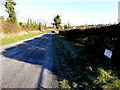
4
Curlagh Townland
Pictured along Curlagh Road
Image: © Kenneth Allen
Taken: 4 Feb 2015
0.04 miles
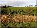
5
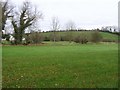
Curlagh Townland
Looking towards Annaghsallagh
Image: © Kenneth Allen
Taken: 16 Nov 2007
0.06 miles