IMAGES TAKEN NEAR TO
Tullyvar Road, AUGHNACLOY, BT69 6BN
Introduction
This page details the photographs taken nearby to Tullyvar Road, BT69 6BN by members of the Geograph project.
The Geograph project started in 2005 with the aim of publishing, organising and preserving representative images for every square kilometre of Great Britain, Ireland and the Isle of Man.

There are currently over 7.5m images from over14,400 individuals and you can help contribute to the project by visiting https://www.geograph.org.uk
Image Map
Images are licensed for reuse under creativecommons.org/licenses/by-sa/2.0
Notes
- Clicking on the map will re-center to the selected point.
- The higher the marker number, the further away the image location is from the centre of the postcode.
Image Listing (4 Images Found)
Images are licensed for reuse under creativecommons.org/licenses/by-sa/2.0
Image
Details
Distance
1
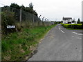
Tullywinny Road
Heading WNW from Tullyvar Road
Image: © Kenneth Allen
Taken: 2 Sep 2014
0.02 miles
2
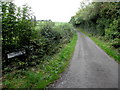
Tullywinny Road, Tullyvar
Heading north-west
Image: © Kenneth Allen
Taken: 2 Sep 2014
0.22 miles
3
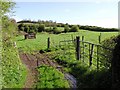
Cavankilgreen Townland
The view is to the north
Image: © Kenneth Allen
Taken: 5 May 2006
0.24 miles
4
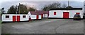
Outbuildings at Shantavney
Located on the main road between Aughnacloy and the Ballygawley roundabout. These old farm buildings are preserved in perfect condition.
Image: © Kenneth Allen
Taken: 7 Nov 2007
0.24 miles