IMAGES TAKEN NEAR TO
Old Bakers Court, BELFAST, BT6 8QX
Introduction
This page details the photographs taken nearby to Old Bakers Court, BT6 8QX by members of the Geograph project.
The Geograph project started in 2005 with the aim of publishing, organising and preserving representative images for every square kilometre of Great Britain, Ireland and the Isle of Man.

There are currently over 7.5m images from over14,400 individuals and you can help contribute to the project by visiting https://www.geograph.org.uk
Image Map
Images are licensed for reuse under creativecommons.org/licenses/by-sa/2.0
Notes
- Clicking on the map will re-center to the selected point.
- The higher the marker number, the further away the image location is from the centre of the postcode.
Image Listing (44 Images Found)
Images are licensed for reuse under creativecommons.org/licenses/by-sa/2.0
Image
Details
Distance
1
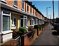
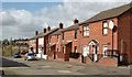
Terraced housing, Belfast
Terraced housing on Ravenhill Avenue in Belfast.
Image: © Rossographer
Taken: 8 Apr 2011
0.12 miles
2
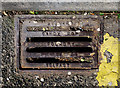
Gully grating, Belfast
Another gully grating from the foundry of James Stewart on Sandry Row in Belfast - this one is located on Ravenhill Crescent. The inscription reads "Stewarts Sandy Row Foundry, Belfast" - in common with other examples found, there is also another line which is unreadable but it may have been a patent number. See also Image for more information.
Image: © Rossographer
Taken: 8 Apr 2011
0.13 miles
3
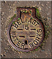
Belfast Water Works cover
Another unknown cover marked "Belfast Water Works". This one is located on Ravenhill Crescent and also features a number 5. This example is in a particularly excellent condition.
Image: © Rossographer
Taken: 8 Apr 2011
0.13 miles
4
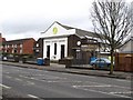
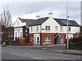
Ulster Temple of the Elim Pentecostal Church, Ravenhill Road
This church building dates from 1931. The Elim Pentecostal Movement was founded in Co. Monaghan in 1915 by a Welshman, Pastor George Jeffreys. It soon spread to Belfast.
http://en.wikipedia.org/wiki/George_Jeffreys_%28pastor%29
Image: © Eric Jones
Taken: 17 Feb 2015
0.13 miles
5
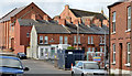
Ballynafoy Close, Belfast - August 2018(1)
Apex Housing Association properties on the eastern side of the Ravenhill Road. The original planning permission (8 May 2011) is “Z/2010/0308/F Demolition of the existing structures on site and the construction of 67 social housing units comprising of 47 terrace houses, 8 apartments and 12 duplex units with associated car parking and landscaping 314 Ravenhill Road, Ballynafoy, Belfast, BT06 8GL” with some subsequent ones referring to minor changes in the type of house.
Image: © Albert Bridge
Taken: 10 Aug 2018
0.13 miles
6
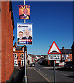
London Road, Belfast
London Road in Belfast. Note the signs - a standard speed humps warning sign for motorists and election posters for the Progressive Unionist Party and the Ulster Unionist Party.
Image: © Rossographer
Taken: 8 Apr 2011
0.15 miles
7
House at the junction of Ballynafoy Road and Ravenhill Road
The next building along is Elim's Ulster Temple.
Image: © Eric Jones
Taken: 17 Feb 2015
0.15 miles
8

Ballynafoy Close, Belfast - August 2018(2)
Mural/street art at the entrance to Ballynafoy Close Image, Ravenhill Road.
Image: © Albert Bridge
Taken: 10 Aug 2018
0.15 miles
9
Gotha Street, Belfast
From what I can find, the original Gotha Street was built towards the end of the 19th century. This is today’s rebuilt version (north western side). The Loopbridge Weaving/Spence Bryson site Image, at Lismore Street, is in the background.
Image: © Albert Bridge
Taken: 14 Apr 2014
0.16 miles
10
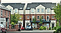
New apartments, London Road, Belfast (April 2014)
See Image (April 2011). The site, between Rochester Street and Delaware Street, is under redevelopment except that, at the time of my visit, the gates were closed and there was nobody present. Image shows the completed block.
Image: © Albert Bridge
Taken: 14 Apr 2014
0.16 miles