IMAGES TAKEN NEAR TO
Lismore Street, BELFAST, BT6 8JS
Introduction
This page details the photographs taken nearby to Lismore Street, BT6 8JS by members of the Geograph project.
The Geograph project started in 2005 with the aim of publishing, organising and preserving representative images for every square kilometre of Great Britain, Ireland and the Isle of Man.

There are currently over 7.5m images from over14,400 individuals and you can help contribute to the project by visiting https://www.geograph.org.uk
Image Map
Images are licensed for reuse under creativecommons.org/licenses/by-sa/2.0
Notes
- Clicking on the map will re-center to the selected point.
- The higher the marker number, the further away the image location is from the centre of the postcode.
Image Listing (101 Images Found)
Images are licensed for reuse under creativecommons.org/licenses/by-sa/2.0
Image
Details
Distance
1
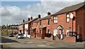
Gotha Street, Belfast
From what I can find, the original Gotha Street was built towards the end of the 19th century. This is today’s rebuilt version (north western side). The Loopbridge Weaving/Spence Bryson site Image, at Lismore Street, is in the background.
Image: © Albert Bridge
Taken: 14 Apr 2014
0.02 miles
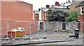
2
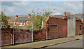
Old factory wall, Belfast - April 2014(1)
An old wall, at Lismore Street, which had once been the wall of the Loopbridge Weaving Company (later Spence Bryson (“Corgi”) Carpets http://www.geograph.org.uk/search.php?i=48222502). The factory has been demolished. There is only vacant ground on the other side. Continue to Image
Image: © Albert Bridge
Taken: 14 Apr 2014
0.05 miles
3
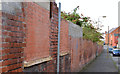
Old factory wall, Belfast - April 2014(2)
See Image The factory wall on the London Road side.
Image: © Albert Bridge
Taken: 14 Apr 2014
0.07 miles
4
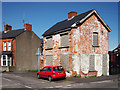
Derelict house, Belfast
A derelict house on the corner of London Road and Rochester Street in Belfast. The house was later demolished - see Image from April 2014.
Image: © Rossographer
Taken: 8 Apr 2011
0.09 miles
5
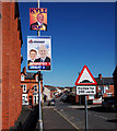
London Road, Belfast
London Road in Belfast. Note the signs - a standard speed humps warning sign for motorists and election posters for the Progressive Unionist Party and the Ulster Unionist Party.
Image: © Rossographer
Taken: 8 Apr 2011
0.10 miles
6
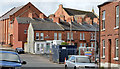
New apartments, London Road, Belfast (April 2014)
See Image (April 2011). The site, between Rochester Street and Delaware Street, is under redevelopment except that, at the time of my visit, the gates were closed and there was nobody present. Image shows the completed block.
Image: © Albert Bridge
Taken: 14 Apr 2014
0.10 miles
7
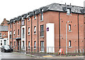
Apartments, 95 London Road, Belfast (June 2017)
See Image The completed block of social housing apartments (Choice Housing Association). Image shows the “before” view in April 2011.
Image: © Albert Bridge
Taken: 23 Jun 2017
0.10 miles
8
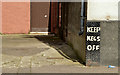
Corner protection, Belfast (April 2014)
Wall and corner protectors can come in many shapes, sizes and materials. This one is on The London Road side of “The Longfellow”, My Lady’s Road.
Image: © Albert Bridge
Taken: 14 Apr 2014
0.11 miles
9
Vacant site, 36 Ravenhill Street, Belfast (June 2017)
A small vacant site, opposite Delaware Street. The following planning permission (28 April 2014) applies “Z/2013/1419/F Infill development of 2 no. townhouses & associated site works 36 Ravenhill Street Belfast BT6 8EP”.
Image: © Albert Bridge
Taken: 23 Jun 2017
0.11 miles
10

Religious graffiti, Belfast (August 2015)
Graffiti, in the form of the word “Jesus”, at My Lady’s Road end of London Road. The reference to Habakkuk 1.5 is “Behold ye among the heathen, and regard, and wonder marvellously: for I will work a work in your days which ye will not believe, though it be told you.”
Image: © Albert Bridge
Taken: 18 Aug 2015
0.11 miles