IMAGES TAKEN NEAR TO
Rosebery Road, BELFAST, BT6 8JE
Introduction
This page details the photographs taken nearby to Rosebery Road, BT6 8JE by members of the Geograph project.
The Geograph project started in 2005 with the aim of publishing, organising and preserving representative images for every square kilometre of Great Britain, Ireland and the Isle of Man.

There are currently over 7.5m images from over14,400 individuals and you can help contribute to the project by visiting https://www.geograph.org.uk
Image Map
Images are licensed for reuse under creativecommons.org/licenses/by-sa/2.0
Notes
- Clicking on the map will re-center to the selected point.
- The higher the marker number, the further away the image location is from the centre of the postcode.
Image Listing (94 Images Found)
Images are licensed for reuse under creativecommons.org/licenses/by-sa/2.0
Image
Details
Distance
1
Gotha Street, Belfast
From what I can find, the original Gotha Street was built towards the end of the 19th century. This is today’s rebuilt version (north western side). The Loopbridge Weaving/Spence Bryson site Image, at Lismore Street, is in the background.
Image: © Albert Bridge
Taken: 14 Apr 2014
0.05 miles
2

Religious graffiti, Belfast (August 2015)
Graffiti, in the form of the word “Jesus”, at My Lady’s Road end of London Road. The reference to Habakkuk 1.5 is “Behold ye among the heathen, and regard, and wonder marvellously: for I will work a work in your days which ye will not believe, though it be told you.”
Image: © Albert Bridge
Taken: 18 Aug 2015
0.08 miles
3
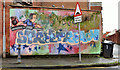
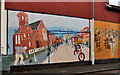
"Streetreach" mural, Belfast (1)
A “Streetreach” mural at the My Lady’s Road Image end of London Road. “Streetreach” was “an initiative to encourage young people from Belfast to go into areas of the city that they may never have gone before, so that they might minister to people and see Christ at work in these places”. Image shows the one in Pearl Street.
Image: © Albert Bridge
Taken: 22 Dec 2011
0.08 miles
4
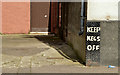
Corner protection, Belfast (April 2014)
Wall and corner protectors can come in many shapes, sizes and materials. This one is on The London Road side of “The Longfellow”, My Lady’s Road.
Image: © Albert Bridge
Taken: 14 Apr 2014
0.08 miles
5
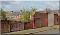
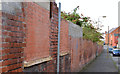
Old factory wall, Belfast - April 2014(1)
An old wall, at Lismore Street, which had once been the wall of the Loopbridge Weaving Company (later Spence Bryson (“Corgi”) Carpets http://www.geograph.org.uk/search.php?i=48222502). The factory has been demolished. There is only vacant ground on the other side. Continue to Image
Image: © Albert Bridge
Taken: 14 Apr 2014
0.09 miles
6
"Streetreach" mural, Belfast (2)
Image: © Albert Bridge
Taken: 22 Dec 2011
0.11 miles
7
Old factory wall, Belfast - April 2014(2)
See Image The factory wall on the London Road side.
Image: © Albert Bridge
Taken: 14 Apr 2014
0.11 miles
8
"The Untold Story" mural, Willowfield, Belfast
A mural, on the southern corner of Canada Street (foreground) and My Lady’s Road Image, recording gratitude for assistance, given by residents of Liverpool, following civil disturbances in the aftermath of the introduction of internment (detention without trial) in August 1971 http://cain.ulst.ac.uk/othelem/chron/ch71.htm#Aug and http://www.belfasttelegraph.co.uk/lifestyle/nostalgia/in-pictures-northern-ireland-troubles-1971-28691865.html. This photograph appears as a matter of neutral geographical and historical record only and does not express any political views of any kind.
Image: © Albert Bridge
Taken: 5 Nov 2013
0.11 miles
9
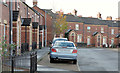
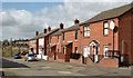
Emerald Street, Belfast (1)
The south western side of a street, running from Pearl Street (behind me) to Cherryville Street, built towards the end of the 19th century and now rebuilt on the same line. Image shows the other side.
Image: © Albert Bridge
Taken: 5 Nov 2013
0.11 miles
10
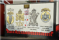
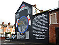
36th (Ulster) Division mural, Willowfield, Belfast (2)
See Image Detail showing the cap badges of four local regiments. There is also an inset depicting the nine who won the Victoria Cross. See also Image
Image: © Albert Bridge
Taken: 5 Nov 2013
0.11 miles