IMAGES TAKEN NEAR TO
Glenwherry Place, BELFAST, BT6 8DJ
Introduction
This page details the photographs taken nearby to Glenwherry Place, BT6 8DJ by members of the Geograph project.
The Geograph project started in 2005 with the aim of publishing, organising and preserving representative images for every square kilometre of Great Britain, Ireland and the Isle of Man.

There are currently over 7.5m images from over14,400 individuals and you can help contribute to the project by visiting https://www.geograph.org.uk
Image Map
Images are licensed for reuse under creativecommons.org/licenses/by-sa/2.0
Notes
- Clicking on the map will re-center to the selected point.
- The higher the marker number, the further away the image location is from the centre of the postcode.
Image Listing (192 Images Found)
Images are licensed for reuse under creativecommons.org/licenses/by-sa/2.0
Image
Details
Distance
1
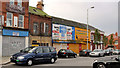
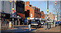
Woodstock development site, Belfast
Long-vacant buildings on the old line of the Woodstock Road, opposite the Woodstock Link. Described on the agents’ board as having planning permission for “15 apartments and ground floor retail unit”. This pillar box Image is behind the taxi on the left. The photograph appears as a matter of record only. I have no connection with any of the parties involved in the sale.
Image: © Albert Bridge
Taken: 16 Nov 2011
0.06 miles
2
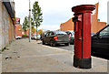
Pillar box, Belfast
EIIR pillar box on the Woodstock Road, opposite the Woodstock Link. This church Image is in the background.
Image: © Albert Bridge
Taken: 16 Nov 2011
0.06 miles
3
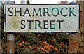
Shamrock Street sign, Belfast
The current style of sign at the Ravenhill Road end of Shamrock Street.
Image: © Albert Bridge
Taken: 22 Mar 2011
0.07 miles
4
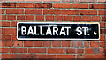
Ballarat Street sign, Belfast
The white-on-black sign on the interestingly-named street off the Ravenhill Road. Sherlock Holmes - The Boscombe Valley Mystery: “Black Jack of Ballarat was the name I went under and our party is still remembered in the colony as the Ballarat Gang.”
Image: © Albert Bridge
Taken: 22 Mar 2011
0.08 miles
5
Zebra crossing, Belfast (3)
A zebra crossing (with central traffic island) on the Ravenhill Road, at My Lady’s Road.
Image: © Albert Bridge
Taken: 18 Jan 2011
0.09 miles
6
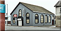
Nos 122-128 Ravenhill Road, Belfast (October 2019)
The Karmel Church (expected to move to another building) with an “agreed” patch on the “for sale” sign. The agents had described it as “Potential for redevelopment to apartments or office accomodation [sic]. Site Area - 437SQ M (0.11) Acres Development site subject to planning permission”.
Image: © Albert Bridge
Taken: 5 Oct 2019
0.09 miles
7
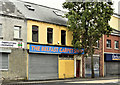
Nos 138 - 140 Ravenhill Road, Belfast (October 2019)
A former carpet shop.
Image: © Albert Bridge
Taken: 5 Oct 2019
0.09 miles
8
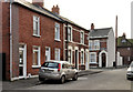
Radnor Street, Belfast
A short street off the Woodstock Road. Shown in the 1877 street directory as having “three small houses”. Subsequently rebuilt, the 1901 edition shows it with 17. Maymount Street Image is on the left.
Image: © Albert Bridge
Taken: 16 Nov 2011
0.09 miles
9
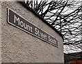
Mount Street South sign, Belfast
Unusual white on dark brown name sign at the My Lady’s Road end of Mount Street South.
Image: © Albert Bridge
Taken: 22 Dec 2011
0.09 miles
10
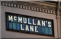
McMullan's Lane, Belfast (2)
The tiled sign at the Ravenhill Road end of McMullan’s Lane Image (northern side).
Image: © Albert Bridge
Taken: 18 Jan 2011
0.09 miles