IMAGES TAKEN NEAR TO
Derrycourtney Road, CALEDON, BT68 4XR
Introduction
This page details the photographs taken nearby to Derrycourtney Road, BT68 4XR by members of the Geograph project.
The Geograph project started in 2005 with the aim of publishing, organising and preserving representative images for every square kilometre of Great Britain, Ireland and the Isle of Man.

There are currently over 7.5m images from over14,400 individuals and you can help contribute to the project by visiting https://www.geograph.org.uk
Image Map
Images are licensed for reuse under creativecommons.org/licenses/by-sa/2.0
Notes
- Clicking on the map will re-center to the selected point.
- The higher the marker number, the further away the image location is from the centre of the postcode.
Image Listing (5 Images Found)
Images are licensed for reuse under creativecommons.org/licenses/by-sa/2.0
Image
Details
Distance
1
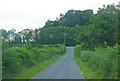
Rising ground along the minor road
The view is looking toward a T junction; photographer is above the paved minor road surface.
Image: © C Michael Hogan
Taken: 14 Jul 2011
0.16 miles
2
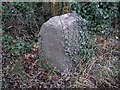
Milestone on the A28
The traffic was so dense, I didn't have time to examine it closely.
Image: © Kenneth Allen
Taken: 16 Nov 2007
0.18 miles
3
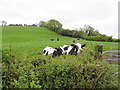
Cattle, Finglush
Pictured along Finglush Road
Image: © Kenneth Allen
Taken: 26 May 2015
0.22 miles
4
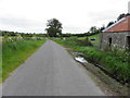
Finglush Road, Finglush
Heading north-east
Image: © Kenneth Allen
Taken: 26 May 2015
0.24 miles
5
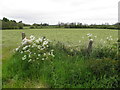
Hemlock, Finglush
Pictured along Finglush Road
Image: © Kenneth Allen
Taken: 26 May 2015
0.25 miles