IMAGES TAKEN NEAR TO
Derrycourtney Road, CALEDON, BT68 4XP
Introduction
This page details the photographs taken nearby to Derrycourtney Road, BT68 4XP by members of the Geograph project.
The Geograph project started in 2005 with the aim of publishing, organising and preserving representative images for every square kilometre of Great Britain, Ireland and the Isle of Man.

There are currently over 7.5m images from over14,400 individuals and you can help contribute to the project by visiting https://www.geograph.org.uk
Image Map
Images are licensed for reuse under creativecommons.org/licenses/by-sa/2.0
Notes
- Clicking on the map will re-center to the selected point.
- The higher the marker number, the further away the image location is from the centre of the postcode.
Image Listing (7 Images Found)
Images are licensed for reuse under creativecommons.org/licenses/by-sa/2.0
Image
Details
Distance
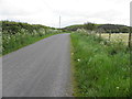
1
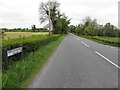
A28 Derrycourtney Road, Curlagh
Heading north-west from the junction with Dromore Road
Image: © Kenneth Allen
Taken: 26 May 2015
0.08 miles
2
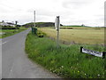
Dromore Road, Curlagh
Heading north-east from the A28
Image: © Kenneth Allen
Taken: 26 May 2015
0.08 miles
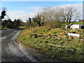
3
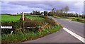
Dromore Road
It is in the townland of Curlagh
Image: © Kenneth Allen
Taken: 7 Nov 2007
0.09 miles
4
Curlagh Townland
Pictured along Dromore Road
Image: © Kenneth Allen
Taken: 26 May 2015
0.15 miles
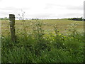
6
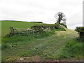
Open fields, Dromore
Pictured along Dromore Road
Image: © Kenneth Allen
Taken: 26 May 2015
0.19 miles
7
Derrycourtney Road, Curlagh
Heading WSW from the A28 road
Image: © Kenneth Allen
Taken: 4 Feb 2015
0.24 miles