IMAGES TAKEN NEAR TO
Church Hill Cottages, CALEDON, BT68 4UX
Introduction
This page details the photographs taken nearby to Church Hill Cottages, BT68 4UX by members of the Geograph project.
The Geograph project started in 2005 with the aim of publishing, organising and preserving representative images for every square kilometre of Great Britain, Ireland and the Isle of Man.

There are currently over 7.5m images from over14,400 individuals and you can help contribute to the project by visiting https://www.geograph.org.uk
Image Map
Images are licensed for reuse under creativecommons.org/licenses/by-sa/2.0
Notes
- Clicking on the map will re-center to the selected point.
- The higher the marker number, the further away the image location is from the centre of the postcode.
Image Listing (57 Images Found)
Images are licensed for reuse under creativecommons.org/licenses/by-sa/2.0
Image
Details
Distance
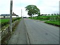
1
Church Hill Road, Caledon
Heading north-east
Image: © Kenneth Allen
Taken: 8 Dec 2015
0.04 miles
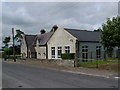
4
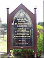
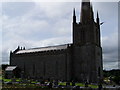
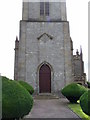
Information Board at St. Johns C.O.I. Caladon
Image: © HENRY CLARK
Taken: 9 Jul 2009
0.06 miles
5
The Church Hill, Caledon
This road forms a loop from the village to the Dyan Road.
Image: © Dean Molyneaux
Taken: 2 May 2010
0.07 miles
6
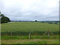
Barley field, Caledon
Looking north-east
Image: © Kenneth Allen
Taken: 30 Jul 2014
0.09 miles
8
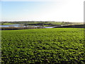
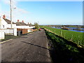
Flooded land at Caledon
Looking south-east from Church Hill Road
Islands have formed along the River Blackwater
Image: © Kenneth Allen
Taken: 8 Dec 2015
0.10 miles
9
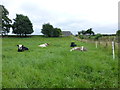
Cows, Caledon
Pictured along Church Hill Road
Image: © Kenneth Allen
Taken: 30 Jul 2014
0.11 miles
10
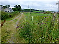
Lane, Caledon
Heading north-west to Church Hill Road
On the right I noticed Image]
Image: © Kenneth Allen
Taken: 30 Jul 2014
0.12 miles