IMAGES TAKEN NEAR TO
Chestnut Manor, CALEDON, BT68 4TY
Introduction
This page details the photographs taken nearby to Chestnut Manor, BT68 4TY by members of the Geograph project.
The Geograph project started in 2005 with the aim of publishing, organising and preserving representative images for every square kilometre of Great Britain, Ireland and the Isle of Man.

There are currently over 7.5m images from over14,400 individuals and you can help contribute to the project by visiting https://www.geograph.org.uk
Image Map
Images are licensed for reuse under creativecommons.org/licenses/by-sa/2.0
Notes
- Clicking on the map will re-center to the selected point.
- The higher the marker number, the further away the image location is from the centre of the postcode.
Image Listing (153 Images Found)
Images are licensed for reuse under creativecommons.org/licenses/by-sa/2.0
Image
Details
Distance
1

Notice board, Caledon Elim Pentecostal Church
Pictured here Image]
Image: © Kenneth Allen
Taken: 30 Jul 2014
0.02 miles
2

Public toilet, Caledon
An impressive looking facility provided by Dungannon and South Tyrone Borough Council.
Image: © Dean Molyneaux
Taken: 2 May 2010
0.03 miles
3
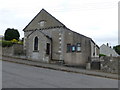
Caledon Elim Pentecostal Church
See close-up of plaque Image]
This simple but attractive stone building is situated on Churchill immediately adjacent to St. John's Church of Ireland Graveyard. It was originally built in 1834 as a Methodist Church Hall accommodating 200 people at a cost of £108. The building is currently in use as an Elim Church.
This information was read here Image]
Image: © Kenneth Allen
Taken: 30 Jul 2014
0.03 miles
4
Ruined building, Caledon
Located at Main Street, I understand that it is to be demolished and rebuilt in the style of the surrounding buildings
Image: © Kenneth Allen
Taken: 30 Jul 2014
0.03 miles
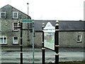
6
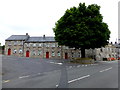
Terraced houses, Caledon
Pictured along Church Hill Road.
Image: © Kenneth Allen
Taken: 30 Jul 2014
0.03 miles
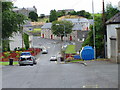
7

The Village Tree, Caledon
An iconic horse chestnut tree at the bottom of the Church Hill in Caledon village.
It is thought to have once been the site of an elm tree (or perhaps a sweet chestnut tree) under which Methodist founder John Wesley preached in 1769.
Image: © Dean Molyneaux
Taken: 2 May 2010
0.03 miles
8
Signs, Dyan Road, Caledon
A variety of signposts and information board - part of the Blackwater Heritage Trail.
Image: © Dean Molyneaux
Taken: 2 May 2010
0.03 miles
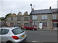
9
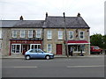
The Salon / Cafe Rose / Gillanders, Caledon
They are located along Main Street.
Image: © Kenneth Allen
Taken: 30 Jul 2014
0.03 miles
10
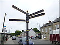
Direction signs, Caledon
Pointing to several notable places
Image: © Kenneth Allen
Taken: 30 Jul 2014
0.03 miles