IMAGES TAKEN NEAR TO
Annesborough Park, CRAIGAVON, BT67 9HU
Introduction
This page details the photographs taken nearby to Annesborough Park, BT67 9HU by members of the Geograph project.
The Geograph project started in 2005 with the aim of publishing, organising and preserving representative images for every square kilometre of Great Britain, Ireland and the Isle of Man.

There are currently over 7.5m images from over14,400 individuals and you can help contribute to the project by visiting https://www.geograph.org.uk
Image Map
Images are licensed for reuse under creativecommons.org/licenses/by-sa/2.0
Notes
- Clicking on the map will re-center to the selected point.
- The higher the marker number, the further away the image location is from the centre of the postcode.
Image Listing (3 Images Found)
Images are licensed for reuse under creativecommons.org/licenses/by-sa/2.0
Image
Details
Distance
1
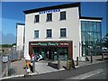
Friar Tuck's Restaurant
It is located at the Lough View Park and Ride Facility near Lurgan
Image: © Kenneth Allen
Taken: 28 Apr 2011
0.16 miles
3
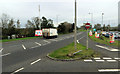
Near Lurgan
A lorry on the A76 heading towards the M1.
Image: © Robert Ashby
Taken: 30 Oct 2013
0.17 miles